
Sedona isn’t the only place nestled in the middle of Mother Nature. Flagstaff sits on the slopes of the San Francisco Peaks. Tucson is sandwiched between the two sides of Saguaro National Park. Even Phoenix has national forest on the northern and eastern edges of its sprawling metropolis. But few places are so nestled in that you can walk from a city park into one of Arizona’s most beautiful wilderness areas. That’s what you get with the Soldier Pass Trail in Sedona.
Technically, you can skip the city park and go directly to the Soldier Pass Trailhead, but its hours are limited (8 a.m. to 6 p.m.), and so are the parking spaces (there are only 14). If you hit it right, consider yourself lucky — this is a very popular trail. Another option is to park at Posse Grounds Park, about a mile to the south. Either way, you’re in for a treat.
From the park, there are two ways to get to the trail, which is named for the soldiers who used the route during the Apache Wars. The Sedona Shuttle runs about every 50 minutes — it’s an excellent way to get from place to place in Red Rock Country. The alternative is to use the Sunrise Trail as a connector. It heads north from the park and segues into Soldiers Pass Road. From there, it’s a short trip to your final destination.
The route begins in the shadow of Coffeepot Rock and immediately dips into a deep wash. As you climb out the other side, you’ll come to a jeep road and an intersection with the Jordan Trail, which veers right, toward the Jim Thompson Trailhead. Turn left onto the jeep road and look right for the Devil’s Kitchen Sinkhole, which is one of seven “recent” sinkholes in the Verde Valley. According the Arizona Geological Survey, the sinkholes occur due to “local subsidence into buried paleokarst caverns of the Pennsylvanian Redwall Limestone.”
In 1968, Albert Thompson, the son of Jim, shared his family story about the day it all went down. “My parents were living in Sedona in the early 1880s and heard the crash when the spot caved in,” he said. “Mother said the dust from the cave-in filled the air all day and the sun looked like it was shining through heavy smoke. Her brother, Jim James, was the first one to see the new hole in the ground.” Be careful as you look in. The sinkhole is steep and deep, about 650 feet, and the rocks around it are loose and slippery.
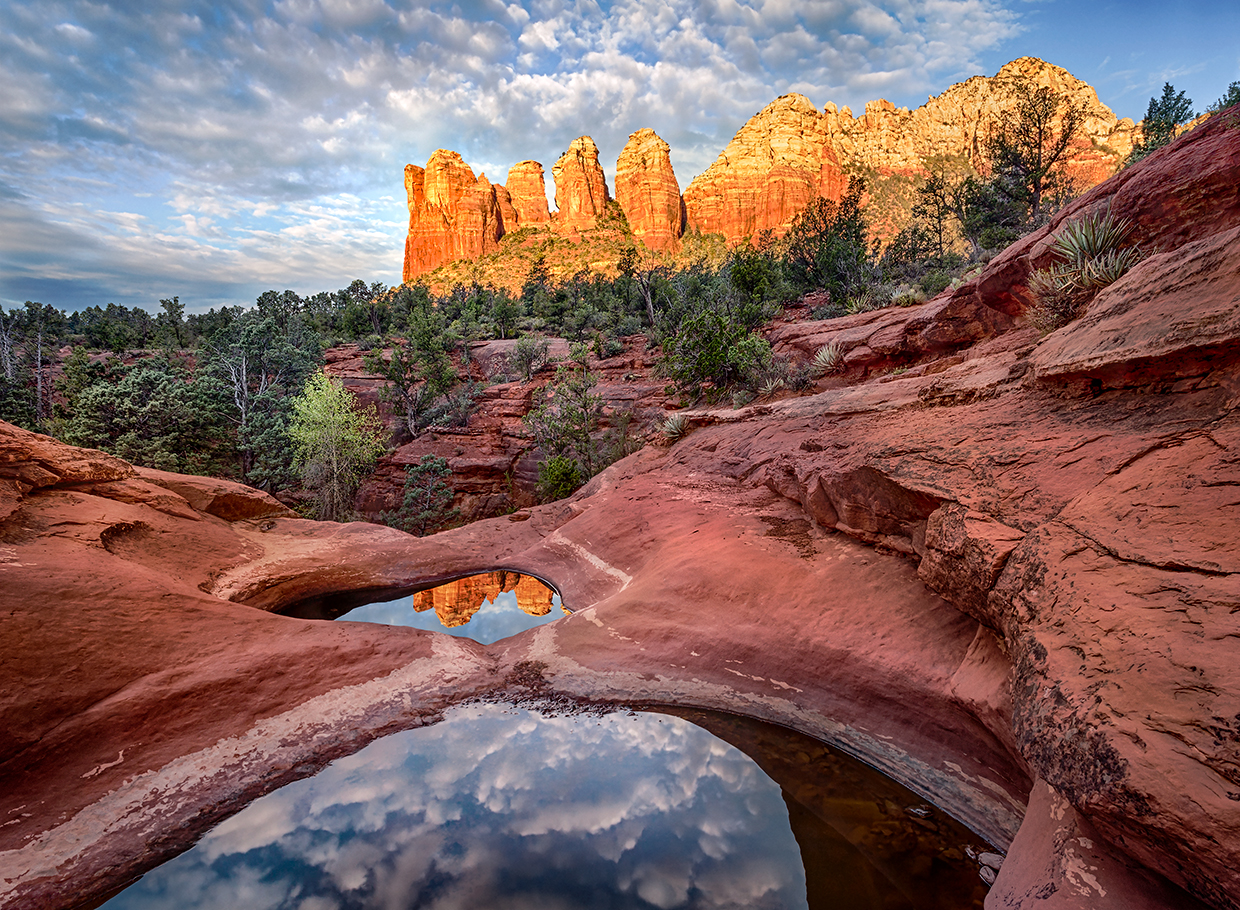
From the big hole, the trail heads northwest to the Seven Sacred Pools. They’re not as impressive as something you’d see in the North Cascades, but the small natural scoops hold water year-round, providing a splash of sustenance for the deer and other wildlife in the area. The pools are hidden in a small canyon to the left. The trail heads right, into a beautiful forest of Arizona cypresses.
About 10 minutes later, you’ll arrive at the Red Rock-Secret Mountain Wilderness, which marks another intersection. To the right is the Soldier Pass Cave Trail, a route that leads to the Soldier Pass Arches. You’ll be headed the other way, into the wilderness area. This is where the payoff begins. Even better, the crowds that might have been making noise early on will have all but disappeared at this point.
Just beyond the wilderness sign, the trail starts to climb out of the canyon. It’s not steep, but the ascent will get your attention as you follow a ridge to the top of Brins Mesa. The views along the way have been classic Sedona, but they’re even better from up on the mesa, where the grade levels off.
A few hundred yards later, you’ll come to a short spur. Veer right and continue a quarter-mile to an intersection with the Brins Mesa Trail. Unless you’re doing a loop (Soldier Pass-Brins Mesa-Cibola Pass-Jordan), this is the turnaround point. As you take in the spectacular panorama, you’ll see Lost Wilson Mountain to the north. And so much more in between. What you won’t see is civilization. Not bad for a hike that begins in a city park.
trail guide
Length: 6.4 miles round-trip (from Posse Grounds Park)
Difficulty: Moderate
Elevation: 4,450 to 4,950 feet
Trailhead GPS: N 34˚52.207', W 111˚46.978'
Directions: From the roundabout intersection of state routes 179 and 89A in Sedona, go southwest on SR 89A for 1.2 miles to Soldiers Pass Road. Turn right onto Soldiers Pass Road and continue 0.5 miles to the trailhead at Posse Grounds Park.
Vehicle Requirements: None
Dogs Allowed: Yes
Horses Allowed: Yes, but the trailhead is not suitable for horse trailers.
USGS Map: Wilson Mountain
Information: Red Rock Ranger District, 928-203-2900 or fs.usda.gov/coconino