
Coconino National Forest, Sedona
Of Sedona’s many scenic wonders, Vultee Arch is among the most impressive. Prior to a plane crash in 1938, however, few people, if any, had ever seen it. Today, it gets its fair share of foot traffic. There are a couple of reasons for that: 1) It’s spectacular to see, and 2) it’s relatively easy to get to.
On paper, the most obvious route is to hike the Vultee Arch Trail from Forest Road 152. The problem with that route is the road — it’s a real bugger. Another option is to hike up from Oak Creek Canyon along the Sterling Pass Trail. It’s more of a workout, but it’s the way to go, especially when you combine it with the Vultee Arch Trail. That’s what we’re doing here.
From the well-hidden trailhead along State Route 89A, you’ll immediately enter the Red Rock-Secret Mountain Wilderness and start climbing. It’s something you’ll have to get used to, because you’re either going up or you’re going down on the Sterling Pass Trail. There’s no in between. No middle ground, no plateaus, no real respites.
After a few short switchbacks, the trail drops into a small drainage surrounded by manzanitas, alligator junipers and thousands of young oak trees. The oaks have prospered in the wake of the Brins Fire, which was started by an illegal, unattended campfire on June 18, 2006. Although the fire scorched 4,000 acres in all, the oaks are signs of hope, and they’re especially impressive in the fall. From the wash, the route to Sterling Pass is easy to follow, but not so easy to climb. It’s an uphill trudge of more than a thousand feet.
Like the canyon, the pass is named for Charles Sterling, an early settler and reputed counterfeiter who allegedly hid out in Oak Creek Canyon. That is, when he wasn’t stealing cattle. The saddle sits between Wilson Mountain and the Mogollon Rim. It also separates Oak Creek Canyon and Sterling Canyon. Enjoy the views, and then get ready to start switching again. Immediately. This time, zigzagging downhill into Sterling Canyon. The terrain is similar to what you’ll have seen coming up, but you’ll enjoy it more because you won’t be gasping for breath.
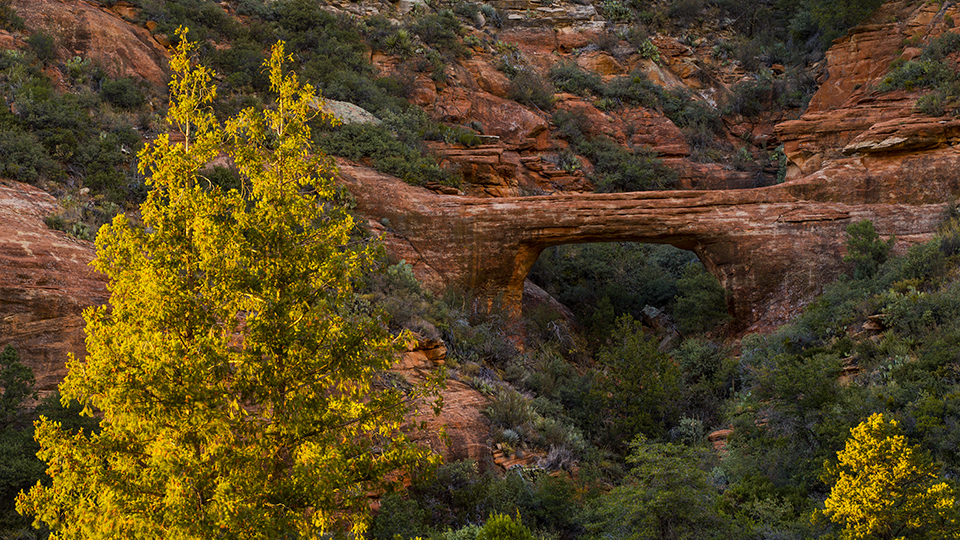
Near the bottom of the canyon, the canopy opens up as the trail winds into thickets of young ponderosa pines — more new growth. A few minutes later, the Sterling Pass Trail ends where the Vultee Arch Trail begins. Continue west and look for a short spur that leads to Vultee Arch, which is named for Gerard Vultee. The story is a sad one: On January 29, 1938, Vultee, an aviation engineer and entrepreneur, and his wife, Sylvia, were flying in a small plane from Winslow to their home in California. Not long after takeoff, they got caught in a blinding snowstorm. Unfortunately, Vultee was flying without instrument training and, presumably, got disoriented. About a mile north of the arch, the plane crashed, and both passengers died.
“The wrecked plane was found near East Pocket, Barney Pasture, just a few hundred feet from the canyon brink leading into the deep, rocky chasm,” The Coconino Sun reported. Despite the tragedy that surrounds it, the arch is one of the most beautiful memorials you’ll ever see.
Back on the Vultee Arch Trail, continuing west, the route follows a small wash and winds through a beautiful grove of spruce trees. There are some big gators in the area, too. And oaks, maples and Douglas firs. Other than the view from the 40-foot span of the arch, this is the best part of the hike.
Eventually, the lush forest gives way to a landscape dotted with agaves, yuccas and manzanitas, as well as Arizona cypresses. This is the look for the next half-mile as the trail leaves the wilderness, enters Dry Creek Basin and arrives at the trailhead at Forest Road 152. Like everything else you’ll have seen along the way, the basin is beautiful. It’s the arch, though, that makes this route spectacular.
Length: 7.2 miles round-trip
Difficulty: Moderate
Elevation: 4,832 to 5,990 feet
Trailhead GPS: N 34°56.198', W 111°44.829'
Directions: From the roundabout intersection of State Route 179 and State Route 89A in Sedona, go north on SR 89A for 6.4 miles to the trailhead on the west side of the road, about a half-mile north of Milepost 380. Park in one of the roadside pullouts across from Manzanita Campground.
Vehicle requirements: None
Dogs Allowed: Yes (on a leash)
Horses Allowed: No
USGS Maps: Munds Park, Wilson Mountain
Information: Red Rock Ranger District, 928-203-2900 or www.fs.usda.gov/coconino