
Prescott National Forest, Prescott
As summits go, Hyde Mountain won’t show up on too many hit lists — peak-baggers usually aim a little higher. Nevertheless, it’s well worth a climb. The drive to the trailhead is scenic, the trail itself is a workout, there’s wildlife along the way, and the summit is the highest point in the Santa Maria Mountains. To top it off, the historic Hyde Mountain Lookout Tower is unlike most of the other fire towers scattered around Arizona. So, even if you are a peak-bagger, you might want to add this one to your list.
From the trailhead, which is located just beyond Camp Wood (an old cavalry post), the rocky track immediately climbs through a cluster of oaks, junipers and small ponderosa pines. This is one of the places where you might see wildlife. Specifically, mule deer, the state’s ubiquitous ungulate. There are granite boulders, as well, similar to those that dot the ground in other parts of the Prescott National Forest. As you climb, you’ll get a nice look at a small scenic side canyon to the left. Then, about 15 minutes in, you’ll see two peaks in the distance. Neither one is Hyde Mountain.
A few minutes later, the trail levels off and enters a small forest of piñons and junipers. If you look up through the trees, you’ll see another peak, one marked by a glint of light. The light is a reflection from the lookout tower. A beacon that leads hikers to the summit. But first, there’s some climbing to do.
Continuing up, the trail passes through a metal gate with a rusted yellow sign — the surrounding evergreens are about 25 feet tall. Before you can say, “This trail is harder than it looks,” you’ll come to a short spur that leads to Brown Spring. Keep right for Hyde, which looks like an ancient pyramid against the distant horizon. After passing a small wash and wading through some tall grasses, the incline ramps up like a drawbridge. As you’re huffing and puffing along, keep your eyes peeled for javelinas, which can be aggressive. Especially if they’re protecting their young.
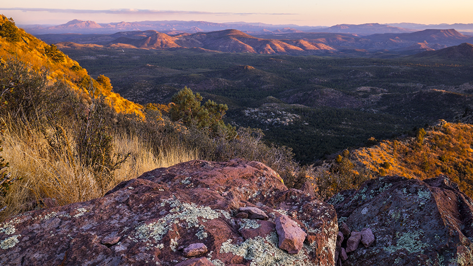
For the next 10 minutes, the trail rises through a heavily wooded area — it’s one of the best segments of the day. Then, the canopy opens up and the trees fade away. The trade-off is a sample of the remarkable panoramas you’ll get in all directions from the summit.
At the 45-minute mark, you’ll come to the trail’s first switchback. It’s a nice respite from the long uphill trudge that came before. After passing a massive alligator juniper, the trail veers east, then south, and then makes a sharp turn to the north. The unmistakable scent of skunk sometimes hangs in the air. Be on the lookout as the trail comes to another big gator — an ancient mystic with multiple trunks. A few steps later, you’ll come to what’s known as the “Lower Saddle,” which is marked by a sign on a stump. Elevation: 6,780 feet.
From the saddle, the grade levels off a little, thanks to some long switches. Then, about an hour in, the trail reaches the “Upper Saddle,” which offers the first views to the west. Jiminy Christmas, you’ll think, if you were born before the Carter administration. (Translation: Impressive.) In addition to that, you’ll see some old metal equipment to the right, and a weathered sign that tells you the lookout tower is just a quarter-mile away. The distance is short, but the grade is steep. And it’s usually very windy up top.
The payoff, however, is a 360-degree panorama that includes the Apache Creek Wilderness to the north, the Connell Mountains to the south, Sawmill Flat to the west and the Chino Valley to the east. And then there’s the lookout tower, which was built in 1936 and is listed on the National Register of Historic Places. Unlike most towers, this one is not on stilts. As you’ll see, you can see forever without them, which is another reason Hyde Peak is a peak worth bagging.
Length: 4.4 miles round-trip
Difficulty: Moderate
Elevation: 5,781 to 7,270 feet
Trailhead GPS: N 34˚49.001', W 112˚54.282'
Directions: From Prescott, go north on Williamson Valley Road for 22 miles to Camp Wood Road (County Road 68). Turn left onto Camp Wood Road, which is gravel, and continue 15.3 miles to Forest Road 95 (at the Camp Wood site). Turn right onto FR 95 and continue 0.2 miles to Forest Road 95C. Turn left onto FR 95C and continue 1.9 miles to the trailhead.
Vehicle requirements: A high-clearance vehicle is required.
Dogs allowed: Yes
Horses allowed: Yes
USGS Map: Camp Wood
Information: Chino Valley Ranger District, 928-777-2200 or www.fs.usda.gov/prescott