
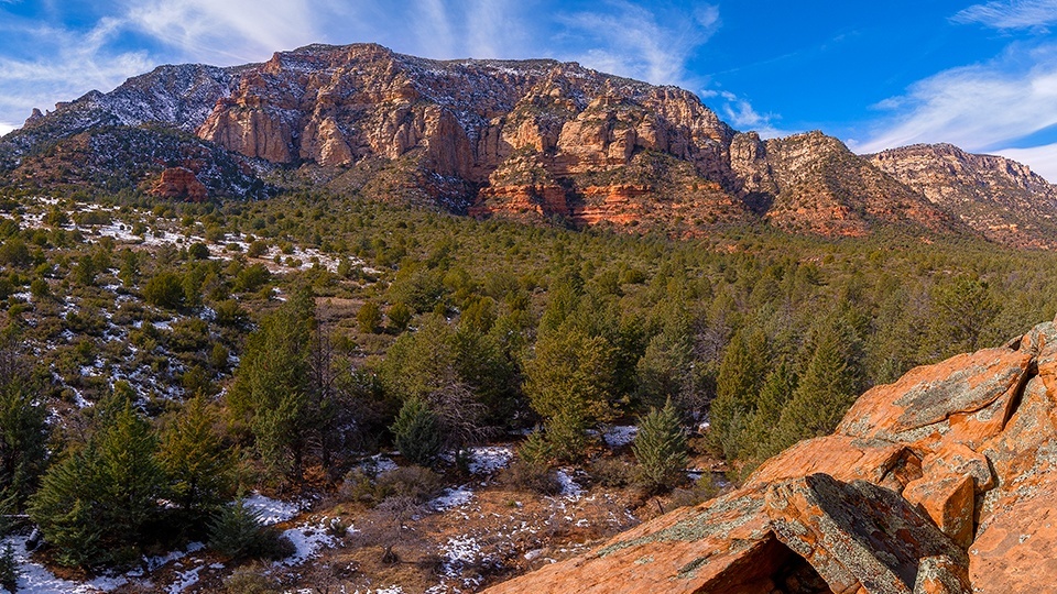
Munds Mountain Wilderness, Sedona
“Huh? Jacks Canyon? No. I’ve never hiked it.”
That’s the response you’ll get from even longtime residents of Sedona. There’s no real explanation for it. The trail is easy to get to. It’s ecologically and geologically diverse. And it leads to one of the best views in Red Rock Country. Still, it doesn’t get a lot of foot traffic. But that’s a selling point, too.
The only minor criticism of the hike is the first mile or so, which parallels a sprawling subdivision. Although the homes interrupt the views, it’s a brief interruption. In addition, the outset is marred a little by the effects of the La Barranca Fire, which burned about 800 acres in 2006. However, it, too, is short-lived, and after a half-hour of following cow paths and dodging thorny brambles, you’ll arrive at the mouth of the canyon, which runs north-south along the east sides of Lee Mountain and Munds Mountain.
From there, the trail begins a slight uphill over rocky ground to Jacks Tank. The tank — like the canyon and the trail — is named for Jack Woods, a railroad engineer from Winslow who grazed sheep in the area in the latter half of the 19th century. The sheep are gone, but everything else remains the same, including the surrounding panorama, which includes the distant summit of Munds Mountain.
Just beyond the tank, the trail narrows and heads downhill to the bottom of the canyon. Then, within a few minutes, it crosses into the Munds Mountain Wilderness, which protects 18,150 acres of habitat that ranges from desert grassland to Douglas firs. You’ll experience both extremes on this trail. You might see some wildlife, too. The wilderness is home to scrub jays, white-throated swifts, red-tailed hawks, mountain lions, mule deer, javelinas, elk, coyotes, foxes, bobcats, rabbits and more.
Seeing wildlife is a matter of chance, but you will see trees. A lot of trees. The majority of this trail cuts through a lush riparian area that’s thick with Arizona cypresses, manzanitas, piñon pines and alligator junipers. There are rocks, too, including some good-sized boulders that have been moved around over the years by snowmelt and monsoon floods. The rubble makes the trail hard to follow at times, but there are usually cairns to mark the way.
Continuing uphill, you’ll move back and forth across the riparian wash. The climb is gradual at the beginning, and for most of the climb, you’ll be in the shade of the trees. However, on occasion, the canopy does open up, allowing glimpses of the multicolored sandstone that lures so many hikers and sightseers to Sedona.
After about 30 minutes in the canyon, the trail steepens. Abruptly. And significantly. And along the way, the vegetation transitions from cypresses and junipers to Gambel oaks and ponderosas. Among the big trees, in the middle of an otherwise remote wilderness, you’ll arrive at a set of steps carved into the rock. It looks like the work of the Civilian Conservation Corps. At the top of the steps, you’ll get your first look at the saddle that separates Munds Mountain and the Mogollon Rim. That’s where you’re headed.
Before you get there, though, you’ll have to conquer a series of steep switchbacks. It’s a workout, but it goes quickly, and after more than three hours of overall hiking, you’ll come to an intersection with the Munds Mountain Trail — it’s around the intersection that you’ll see the Douglas firs. If you’re out of gas, and you might be, the saddle is a good turnaround point. However, if you have anything left, the Munds Mountain Trail continues for less than a mile to the summit of Munds Mountain.
Of all the great lookouts in Sedona, this might be the best. From the top, you can see Schnebly Hill Road down below, Oak Creek Canyon to the north and the Verde Valley to the south. Make some photos, post them to Instagram and then find your way to the broad meadow that covers the summit. As you’ll see, it’s a good place to hang out and catch your breath. What’s more, there’s a good chance you’ll have the summit all to yourself.
Length: 15 miles round-trip
Difficulty: Strenuous
Elevation: 4,278 to 6,825 feet
Trailhead GPS: N 34˚47.090', W 111˚43.932'
Directions: From Interstate 17, go west on State Route 179 (Exit 298) for 7.3 miles to Jacks Canyon Road. Turn right onto Jacks Canyon Road and continue 2 miles to an unnamed dirt road on the right (there’s a small trailhead sign). Turn right onto the dirt road and continue 0.1 miles to the trailhead.
Vehicle Requirements: None
Dogs Allowed: Yes
Horses Allowed: Yes
USGS Maps: Munds Mountain, Sedona
Information: Red Rock Ranger District, 928-203-2900 or www.fs.usda.gov/coconino