
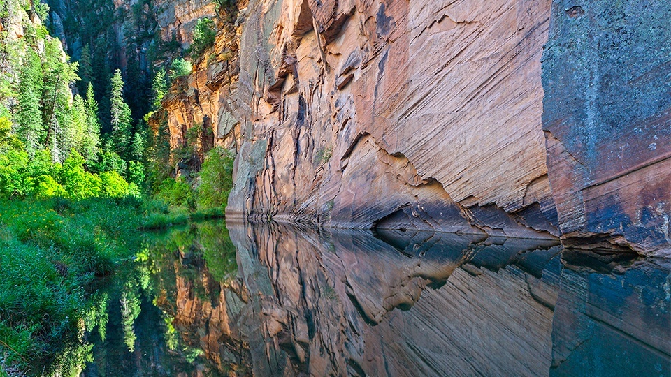
Coconino National Forest, Verde Valley
Sand dunes, snakes, scorpions ... there’s a long list of stereotypes about Arizona. Although there is sand in the state, along with venomous reptiles and eerie invertebrates, there’s more to the landscape than that. There are mountains, meadows, lakes, rivers and creeks, too. And one of the most impressive creeks is West Clear Creek. It’s an unexpected oasis that shatters stereotypes and nourishes an array of plants and trees, including hanging gardens of maidenhair ferns, scarlet penstemons, columbines, cottonwoods, sycamores, bigtooth maples, Douglas firs, Arizona walnuts, willows, ash and ponderosa pines. And there’s wildlife, too. Everything from black bears, elk, mountain lions and mule deer to skunks, badgers and bobcats. It’s one of the most beautiful places anywhere.
You’ll get a sense of just how spectacular it is as you drive in. Although Forest Road 215 is a little rough in places, the road offers terrific views of the canyon into which you’ll be hiking — as you look down, your Lewis and Clark impulses will shift into overdrive.
The trailhead is located at the end of the bumpy road, at a place called Bull Pen Ranch. From there, the route passes under a canopy of impressive sycamores and piggybacks an old ranch road on the north bank of the creek. Then, after about a mile, it cuts south for the first of four stream crossings. Throughout most of the year, other than the wet season, it’s a simple hop, skip and jump to the other side. In fact, if you’re even somewhat agile — you don’t have to be one of the Flying Wallendas — you can maneuver over the rocks and logs without getting wet. Be careful, though. Anything you step on will be slippery.
Heading east on the south side of the perennial creek, the trail meanders through a lush riparian forest and quickly comes to the second creek crossing, followed by the official boundary of the West Clear Creek Wilderness. Looking around, you’ll understand why Congress protected 15,468 acres of this canyon in 1984. Although it’s less than 2 miles wide, the canyon winds for nearly 40 miles through some of the most scenic and least visited terrain in Arizona, making it the longest of the many canyons that cut through the Mogollon Rim.
As you cross into the wilderness, you’ll see Black Mountain to the south and the Blodgett Basin to the north. In between those two points are three major layers of rock: Supai formation, Coconino sandstone and volcanic deposits. The Lower Supai was laid down in the Pennsylvanian Period of the Paleozoic Era. Back then, Arizona was mostly under a shallow sea. Whatever might have been swimming in that water is long gone, but fossils remain. There are human artifacts, too, left by the ancient Sinagua people who lived in the canyon hundreds of years ago. Keep in mind, if you do find an ancient relic, it’s a federal offense to remove it or disturb it. Look. Don’t touch.
Continuing on, the trail parallels the beautiful creek. Then, after 5.5 miles and a fourth creek crossing, you’ll come to a point where the trail veers north, away from the water. This is our recommended turnaround point. Just retrace your steps and enjoy the views. However, if you’re in excellent condition and you want to extend the hike, follow the trail north through a draw that climbs almost 2,000 feet in 2 miles. It’s a brutal ascent to an upper trailhead located along Forest Road 214A. From there, you’ll follow FR 214A and Forest Road 214 for 1.3 miles to the upper end of the Blodgett Basin Trail, which was built to move cattle between seasonal pastures. It’s a 2.5-mile route that leads back to Bull Pen Ranch and completes a 15-mile loop.
Obviously, you’ll get a bigger notch in your belt for taking the long way, but there’s no shame in staying down by the water. The hike is just as impressive in reverse. What’s more, it’s a good way to shatter any lingering stereotypes.
Length: 11 miles round-trip
Difficulty: Easy
Elevation: 3,700 to 4,100 feet
Trailhead GPS: N 34˚32.338', W 111˚41.510'
Directions: From Interstate 17 near Camp Verde, go southeast on State Route 260 for 7.9 miles to Forest Road 618. Turn left onto FR 618 and continue 2.2 miles to Forest Road 215. Turn right onto FR 215 and continue approximately 3 miles to the trailhead at Bull Pen Ranch.
Vehicle Requirements: A high-clearance vehicle is recommended.
Dogs Allowed: Yes (on a leash)
Horses Allowed: Yes
USGS Maps: Walker Mountain, Buckhorn Mountain
Information: Red Rock Ranger District, 928-282-4119 or www.fs.usda.gov/coconino