
Like Jean-Jacques Rousseau wandering the province of Savoy, you could hike alone in the Juniper Mesa Wilderness a dozen times and never see another soul. It’s remote, which explains why. But it’s not excessively so. And there’s a pretty good road that leads to an established trailhead. Yet the 7,566-acre wilderness area doesn’t get a lot of foot traffic. Those who do find their way tend to come from a small group of enlightened locals, like Laura, Trale and their young son Summit. They like to hike the Happy Camp Trail, which climbs to an elevation of more than 7,000 feet near Gobbler Knob. Happy Camp is one of the more strenuous trails in the area. One of the easiest is the Bull Springs Trail.
It begins on the Oaks & Willows Trail, at the southern end of George Wood Canyon. Large boulders, ponderosa pines and a giant alligator juniper mark the way. The vegetation in this mountain range varies according to exposure. On the south-facing slopes, you’ll find mostly piñon pines and Utah junipers, while the north-facing slopes feature alligator junipers and ponderosa pines. There are several varieties of oaks, too. Together, they create a canopy that makes this trail an option even in the middle of summer.
Just beyond the big gator, you’ll come to the North Fork of Walnut Creek, which may or may not have running water. Use caution either way when crossing, and when you get to the other side, veer right and climb the small embankment. A few minutes later, you’ll come to an intersection with the Bull Springs Trail. The Oaks & Willows Trail makes a hard left. The BST veers right and offers a great look at the Santa Maria Mountains to the south. If you squint, they’re reminiscent of the Adirondacks.
From the intersection, the route heads east on a rocky single track that can be hard to follow. Cairns help guide the way, but they tend to get knocked down, so you’ll need to pay attention. Also, the rocks increase the risk of rolling an ankle — it’s a path better suited for mammals with hoofs instead of hiking boots. Watch your step, and after a couple of short switchbacks, look for a 90-degree shift to the left. You can’t afford to miss this turn.
Continuing on, the trail cuts to the northeast and starts to climb. There aren’t any more switchbacks, and the canopy disappears. It’s along this stretch that you’ll huff and puff a little. But it’s a short stretch with a nice view of Juniper Mesa, which is characterized by its abrupt south-facing cliff. The rocks you’ll see are Tapeats Sandstone, Martin Limestone and Redwall Limestone — there’s more than a billion years of geological history along this trail. After 10 minutes out in the open, you’ll arrive at the boundary of the Juniper Mesa Wilderness and cross back into the woods.
Although there aren’t any perennial streams in this wilderness area, wildlife is relatively abundant. If you move quietly, you might get lucky and see mountain lions, black bears, elk, mule deer, bobcats and coyotes. But even if you don’t, the trail at this point offers a beautiful walk in the woods. It’s the best part of the hike. Take it slow, and after about 15 minutes, you’ll come to Bull Spring, which drip, drip, drips into an old cattle tank surrounded by a thick stand of oaks and other deciduous trees.
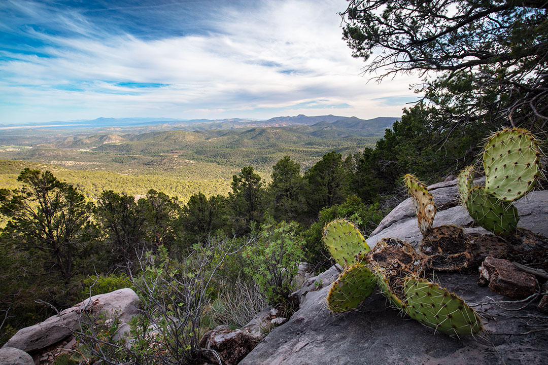
This is the turnaround point for this hike. However, if you have time, water and a little more energy, the BST continues for another quarter-mile to the Juniper Mesa Trail — the east-west route through the wilderness area. The final stretch is steep and rocky, but the views from the top of the mesa are hard to beat. To the south, you can see the Apache Creek Wilderness and Granite Mountain. To the north, the Woodchute Wilderness and Sycamore Canyon. And to the west, the extensive land holding known as Baca Float No. 5, which for many years was owned by the Greene Cattle Co., the legendary empire founded by self-titled “Colonel” William Greene. That land is off-limits, but it doesn’t matter. More than likely, you’ll have Juniper Mesa all to yourself. And that’s more than enough.
Trail guide
Length: 3.75 miles round-trip
Difficulty: Easy
Trailhead GPS: N 34˚56.449', W 112˚57.116'
Elevation: 5,924 to 6,486 feet
Directions: From the intersection of Pioneer Parkway and Williamson Valley Road in Prescott, go north on Williamson Valley Road for 33.6 miles to County Road 125 (West Walnut Creek Road) — after 19.6 miles,
Williamson Valley Road transitions from pavement to gravel. Turn left onto CR 125 and continue 8.4 miles, past the Walnut Creek Ranger Station, to the George Wood Canyon Trailhead, on the right. (Note: Bear right at the two forks in the road beyond the ranger station.)
Vehicle Requirements: A high-clearance vehicle, such as an SUV or truck, is recommended on County Road 125.
Dogs Allowed: Yes (on a leash)
Horses Allowed: Yes
USGS Map: Juniper Mountains
Information: Chino Valley Ranger District, 928-443-8000 or fs.usda.gov/prescott