
There’s no definitive set of variables that define a perfect hike. It varies from person to person and place to place. In the arid Southwest, water is an important element. Scenery, accessibility and difficulty are part of it, too. And so is a nice payoff. By those measures, the Bell Trail would seem to have it all. What’s more, it’s doable any time of year, and the best time might be autumn, when the riparian canopy of cottonwoods and sycamores turns to gold. The only downside is the foot traffic, which can be heavy at times. But if you go on a weekday, you’ll find plenty of solitude. And getting there is easy.
The trailhead is located a stone’s throw from the Sedona exit off Interstate 17. Actually, there are two trailheads, which can be a little confusing. The first is the Bruce Brockett Trailhead, which features a large parking area that can accommodate horse trailers. It’s good for RVs, too. But anyone can park there — from the lot, there’s a short connector trail that leads to the Bell Trail. The primary trailhead, however, is a quarter-mile farther down the road. There’s a restroom and plenty of parking.
From that lot, the trail begins as a wide, rocky red-dirt path. Almost immediately, you’ll start to hear the sounds of Wet Beaver Creek, which runs year-round and is home to smallmouth bass and trout. About 10 minutes in, the trail dips down and passes through a fence. To the south is the riparian area, one of the most beautiful in Arizona. And to the north is a hillside covered with grasses and prickly pear cactuses. If the sun is shining and the time is right, the plants look as if they’re being illuminated with fiber optics.
A few minutes later, you’ll arrive at an intersection with the Bruce Brockett Trail, which leads to the horse trailer lot and is named for the late poet, politician and cattleman who owned the surrounding V Bar V Ranch. The ranch was acquired by the Coconino National Forest in 1994, and a portion of it was preserved as the V Bar V Heritage Site. Today, that area — about a mile down the road — is known as the Crane Petroglyph Heritage Site, and it protects one of the largest and best-preserved petroglyph sites in the Verde Valley.
Continuing on, you’ll come to the first of several short spurs that lead to the creek. A few minutes later, there’s a second spur, followed by an intersection with the White Mesa Trail, which runs north for about a mile toward its namesake. Ten minutes after that, you’ll come to an intersection with the Apache Maid Trail, a strenuous route that runs northeast past Casner Butte (5,121 feet). Just beyond that junction, the trail crosses into the Wet Beaver Wilderness, which was established in 1984 and protects 6,178 acres.
Visually, the landscape doesn’t change much, but the trail shifts from mostly level to a gradual ascent. It’s not a strenuous climb, but it’s enough to get your attention. Keep in mind, the ascent will fool you at times. More than once, you’ll think you’ve arrived at the high point of the hike, only to turn a corner and see that there’s more uphill ahead.
After a half-mile of deceit, you’ll arrive at a narrow bench that runs along the canyon’s north wall. The trail levels off briefly and passes some spectacular ocotillos, like something you’d see in the foothills of the Santa Rita Mountains. After that, it starts climbing again until it reaches an elevation of 4,265 feet — the official high point. From there, the single track drops into the canyon and arrives at Wet Beaver Creek, at a place known as Bell’s Crossing.
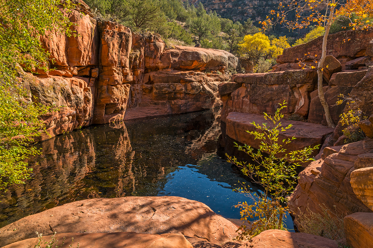
Although the Bell Trail continues uphill for another 3.2 miles to an intersection with the Long Canyon Trail, this is where most folks turn around. Big trees shade the water, creating an oasis that’s best known for “The Crack,” a natural pool that was listed in National Geographic Adventure as one of the nation’s best swimming holes. Sadly, that great magazine is no longer in print, but The Crack remains, and it’s the payoff on a trail that seems to have it all.
Trail guide
Length: 7 miles round-trip (to Bell’s Crossing)
Difficulty: Moderate
Elevation: 3,867 to 4,265 feet
Trailhead GPS: N 34˚40.451', W 111˚42.801'
Directions: From Phoenix, go north on Interstate 17
to State Route 179 (Exit 298). From the exit, turn right onto Beaver Creek Road (Forest Road 618) and continue 2 miles to Forest Road 618A. Turn left onto FR 618A and continue a quarter-mile to the trailhead parking lot.
Vehicle Requirements: None
Dogs Allowed: Yes (on a leash)
Horses Allowed: Yes
USGS Maps: Casner Butte, Walker Mountain
Information: Red Rock Ranger District, 928-282-4119 or fs.usda.gov/coconino