
Sunset Crater Volcano and Wupatki National Monuments
Pick up a course catalog for Northern Arizona University, and you'll find the usual list of electives: history, geology, archaeology. It's not rocket science, but if you want to learn about yesteryear, voclanoes and artifacts, NAU is a great place to start.
Another option is a Sunday drive through Sunset Crater Volcano and Wupatki national monuments. History, geology and archaeology, as well as many other “ologies,” are part of the education you’ll get on this 73-mile scenic loop. Of course, if you’d rather just sit back and enjoy the ride, you can do that, too.
The paved loop begins near Bonito Park Campground, which sits in the shadows of Sunset Crater. Before you take off, take a look around. Virtually every mountain you’ll see is volcanic — in all, there are 600 volcanoes in the area. Sunset Crater is the youngest, and like its many siblings, it’s dormant. In A.D. 1040, however, it blew its top. The eruptions continued, on and off, for almost 200 years, eventually creating the 1,000-foot cinder cone we see today.
The Navajo call it “Yellow-topped Mountain”; the Hopi call it “Red Hill.” In 1885, Colorado River explorer John Wesley Powell penned his own description: “A portion of the cone is of bright reddish cinders, while the adjacent rocks are of black basalt. The contrast in the colors is so great that on viewing the mountain from a distance the red cinders seem to be on fire. From this circumstance, the cone has been named Sunset Peak ... which seems to glow with a light of its own.”
Regardless of its renown, the Northern Arizona landmark was almost destroyed in 1928 when a movie production company wanting to film a landslide proposed blowing up the crater. Fortunately, the locals weren’t crazy about the idea, and pushed for the crater’s protection, which it received on May 26, 1930, when President Herbert Hoover established Sunset Crater National Monument. The word “Volcano” was added to the name in 1990, and today, the park comprises 3,040 acres surrounded by the Coconino National Forest.
The crater itself is the main attraction in the monument, and one of the best ways to see it is by hiking the fire lookout road that meanders up O’Leary Peak — the turnoff is just before the visitors center. A few miles farther is the Bonito Lava Flow. If you’ve never been to the moon, this is what it looks like. In fact, it’s so lunar-like, NASA had its Apollo astronauts (including Neil Armstrong) train here in the 1960s.
There’s a short trail you can take to experience the rocks — you’ll feel like you’re climbing around in Mother Nature’s barbecue grill. Near the base of the crater, another trail passes squeeze-ups, fumaroles and clinkers (volcanic terms worth learning about in person).
Heading north from the higher elevations near Sunset Crater National Monument to the desert grasslands of Wupatki National Monument you’ll eventually come upon the abandoned ruins of the Sinagua people.
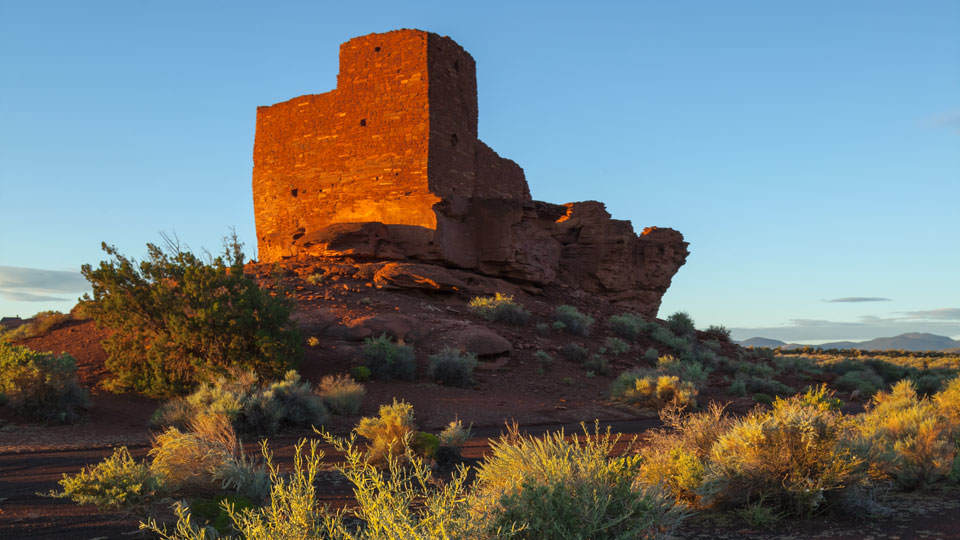
The Sinaguans (our name, not theirs) were farmers who were forced north by Sunset Crater’s eruption and learned to use the dark ash as a kind of mulch, which conserved the area’s scarce moisture longer than the native soil. Modern science would later demonstrate that cinder ash also aids in corn germination and growth. Drought eventually forced the Sinaguans out, but in their wake, they left behind a series of magnificent structures — most of their stone homes are so well preserved that even present-day visitors think they’ve been restored. They’re not.
To date, archaeologists have mapped and studied more than 2,500 sites within Wupatki National Monument. The largest of these pueblos — Wukoki, Lomaki and Wupatki — are open to the public. In its heyday, Wupatki contained more than 100 rooms, and things stayed mostly intact until the 1880s, when sheepherders used the ruins as a camp. Although looters eventually cleaned them out, they’re definitely worth a look.
From the ruins, the rest of the loop winds for about 10 miles back to U.S. Route 89. It’s a peaceful drive, and with all the history, geology and archaeology out of the way, it’s the perfect time to sit back and enjoy the ride.
Note: Mileages are approximate.
Distance: 73-mile loop (from Flagstaff)
Directions: From Flagstaff, go north on U.S. Route 89 for 12 miles to the Sunset Crater-Wupatki National Monument turnoff (Forest Road 545). Turn right onto FR 545 and continue 34.5 miles through both monuments, then back to U.S. 89. Turn left onto U.S. 89 and continue 26.5 miles back to Flagstaff.
Vehicle requirements: None
Information: Sunset Crater Volcano National Monument, 928-526-0502 or www.nps.gov/sucr; Wupatki National Monument, 928-679-2365 or www.nps.gov/wupa
Travelers in Arizona can visit www.az511.gov or dial 511 to get information on road closures, construction, delays, weather and more.