
Sycamore Canyon Wilderness, Coconino National Forest
You probably won't see any parsons along this trail. Priests, rabbis, nuns ... none of them. In fact, there's a good chance you won't see anybody. Unlike the Red Rock/Secret Mountain Wilderness to the east, the Sycamore Canyon Wilderness is relatively unknown. But don't let the lack of foot traffic give you the wrong idea. This trail explores one of the most spectacular riparian areas in the state.
The centerpiece of the wilderness, which was established in 1935, is the canyon itself. In all, it winds for more than 20 miles along Sycamore Creek, a spectacular waterway that might be even more impressive than the canyon. It's the water, of course, that gives life to the area's wide array of vegetation, including cottonwoods, sycamores and Arizona walnuts. And there's wildlife, too. Golden eagles, mountain lions, bobcats, badgers, great blue herons and black bears all call this place home. Most of these creatures are elusive, but you never know.
The trail begins with a steep drop of about 200 feet from the rim to the canyon floor. After that, things remain mostly level all the way to the spring, which is just shy of 4 miles away. The first thing you'll notice along the bottom of the canyon is the trail itself. It's smooth and sandy and easy on the feet, and in the fall it'll be covered with autumn leaves. You'll also notice the water. You'll hear it initially, then, after about 10 minutes, you'll come to the first of many small pools. The first pool even has a miniwaterfall.
Another thing you'll notice is the quiet. It's so still that even the leaves can be heard hitting the ground. Literally. The trail continues like this for about a half-hour, at which point you'll come to the first of several creek crossings. Although this hike is rated Easy, it does require some boulder-hopping and some concentration. All of the crossings are marked with cairns, but some can be hard to find. This area floods regularly, which obliterates many of the markers. Look closely and you'll see where to go.
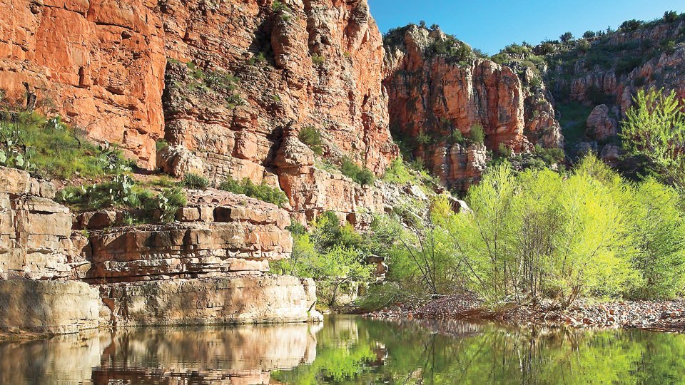
After a couple more creek crossings and about 15 minutes of hiking, the largest pool along the hike will come into view. To get there, you'll have to detour off the trail about 100 feet, but the extra steps are mandatory. Compared to every other water hole along the way, this one is Lake Superior. It's gorgeous. And completely unexpected. It varies in size, depending on the weather, but in general, it's at least as big as an Olympic-sized swimming pool. What makes it even more impressive is the wall of rock that surrounds it. The cliffs of Sycamore Canyon are a unique mix of dark columnar basalt, buff-colored limestone and red sandstone. At the big pool, the red rocks are dominant. Both in scale and color.
Beyond this point, the trail climbs away from the creek and skirts a canyon wall for about 20 minutes. Then, it's back and forth across the creek until you come to Parsons Spring, which pumps out more than 5,000 gallons a minute. It's water that turns an otherwise dry streambed into a perennial creek. As you're sitting there eating your trail mix, you'll be wondering why more people don't visit this idyllic place. Although there aren't any parsons or priests in the area, the hike evokes all kinds of spiritualism, and for those who worship Mother Nature, it's a religious experience.
Length: 7.4 miles round-trip
Difficulty: Easy
Elevation: 3,775 to 3,671 feet
Directions: From Cottonwood, drive northwest on Main Street and follow the signs toward the turnoff for Tuzigoot National Monument. Turn right onto Tuzigoot Road, continue across the Verde River bridge, and turn left onto Forest Road 131 (Sycamore Canyon Road). From there, it's 11 miles to the trailhead.
Vehicle Requirements: A high-clearance vehicle is required.
Dogs Allowed: Yes (on a leash)
Horses Allowed: Yes, but only to the 3-mile mark at the third crossing of Sycamore Creek.
USGS Map: Sycamore Basin, Clarkdale
Information: Red Rock Ranger District, 928-282-4119 or www.fs.fed.us/r3/coconino