
Kaibab Plateau, Kaibab National Forest
Have you ever put on a jacket for the first time in months and found a dollar in the pocket? Have you ever done that, then reached into the other pocket and found 20 dollars? If so, you’re pretty lucky. And you also have some idea of what the drive to Marble Viewpoint, on the Kaibab Plateau, feels like. At the end of this gorgeous drive, you’ll reach a nice vista that you’ll think is the destination. And then you’ll go a little farther, and … wow.
But this 12.8-mile journey offers plenty of beauty before that — starting at DeMotte Park, one of several picturesque meadows along the North Rim Parkway (State Route 67), which leads to the Grand Canyon’s North Rim. From the highway, head east on Forest Road 611, which is near DeMotte Campground and Kaibab Lodge. After crossing a small bridge, the road turns to gravel as it climbs into a forest of tall ponderosa pines. The road is mostly in excellent condition, but a high-clearance vehicle is advisable for the rough patches. The same is true of Forest Road 610, onto which you’ll turn right after 1.3 miles.
You’ll start to see evidence of forest thinning — this road was used as a firebreak during the 2016 Fuller Fire, which scorched a section of the Kaibab National Forest and part of Grand Canyon National Park. Thankfully, the fire doesn’t appear to have made it to FR 610, which runs south before turning east and skirting the park’s northern boundary. At Mile 6.3, you’ll pass through two grassy meadows ringed by aspens and ponderosas. They’re good places to spot wild turkeys or mule deer, and if you stop for a picnic lunch, don’t be surprised if a Steller’s jay tries to steal a bite.
Eight miles into the drive, you’ll turn left onto Forest Road 219 and head north. Thick stands of aspens line both sides of this road, which is narrower than the previous two. Even up here, you’ll be thankful for the shade the aspen canopy provides on a summer afternoon. The road gets more rutted around Mile 10, so proceed carefully until Mile 12.5, when you’ll arrive at a clearing, on the left, with a sign that reads, “Marble Viewpoint.”
Hmmm, you’ll think. This is … nice. And it is nice — there’s a good view of a pine-covered ridge to the west. But not much else. This is it, right? There’s a sign and everything. And then, just northeast of the clearing, you’ll see a small road that’s marked as Forest Road 219AB. Huh. I wonder where that leads.
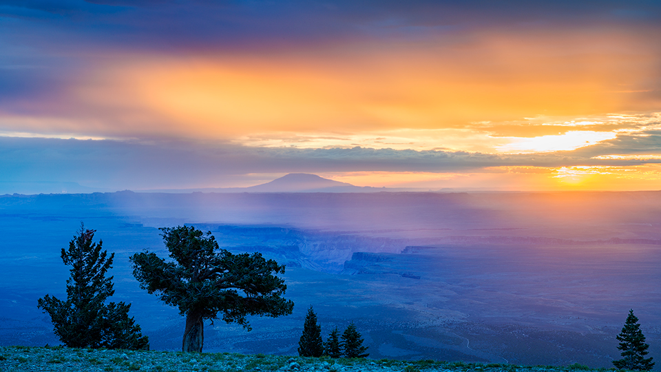
After a quarter-mile drive through some ponderosas, you’ll find out: a huge clearing, jutting from the plateau, that offers seemingly limitless views. Among them are the Saddle Mountain Wilderness just below the viewpoint, the unmistakable profile of Marble Canyon to the east and the Vermilion Cliffs to the north. You’ll feel very lucky. And, if it’s windy, maybe a little cold. So put on a jacket. And make sure you check the pockets.
Note: Mileages are approximate.
Length: 12.8 miles one way (from North Rim Parkway)
Directions: From Jacob Lake, go south on the North Rim Parkway (State Route 67) for 26.3 miles to Forest Road 611. Turn left (east) onto FR 611 and continue 1.3 miles to Forest Road 610. Turn right onto FR 610 and continue 6.7 miles to Forest Road 219. Turn left onto
FR 219 and continue 4.5 miles to Forest Road 219AB. Turn right onto FR 219AB and continue 0.3 miles to Marble Viewpoint.
Vehicle requirements: A high-clearance vehicle is recommended.
Warning: Back-road travel can be hazardous, so be aware of weather and road conditions. Carry plenty of water. Don’t travel alone, and let someone know where you are going and when you plan to return.
Information: North Kaibab Ranger District, 928-643-7395 or www.fs.usda.gov/kaibab