
Coconino National Forest, Sedona
Had he gotten there a little sooner, Jim Thompson might have spent his days nibblin’ on sponge cake and watchin’ the sun bake. That’s because 70 million years ago, Sedona was a coastal landscape beside a tropical sea. However, by the time Mr. Thompson took his squatter’s rights in what we know today as Oak Creek Canyon, erosion had worked its magic and made the Sedona area one of the most recognizable landscapes in the world. It’s also one of the best places to take a hike.
Of the many trails in Red Rock Country, the Jim Thompson Trail is one of the easiest. It’s easy to hike, and it’s easy to get to. But before you get started, you should know there are two established trailheads. The best option is the Jim Thompson Trailhead. It’s just a few blocks from the pink jeeps and turquoise jewelers, and there’s a lot of parking. The alternative, which is usually congested, is at Midgley Bridge, right before State Route 89A enters Oak Creek Canyon.
From the Thompson end, the trail begins on the north side of the dirt parking lot and immediately drops into a wash. Junipers, piñons and manzanitas line the rocky, sandy path. After about
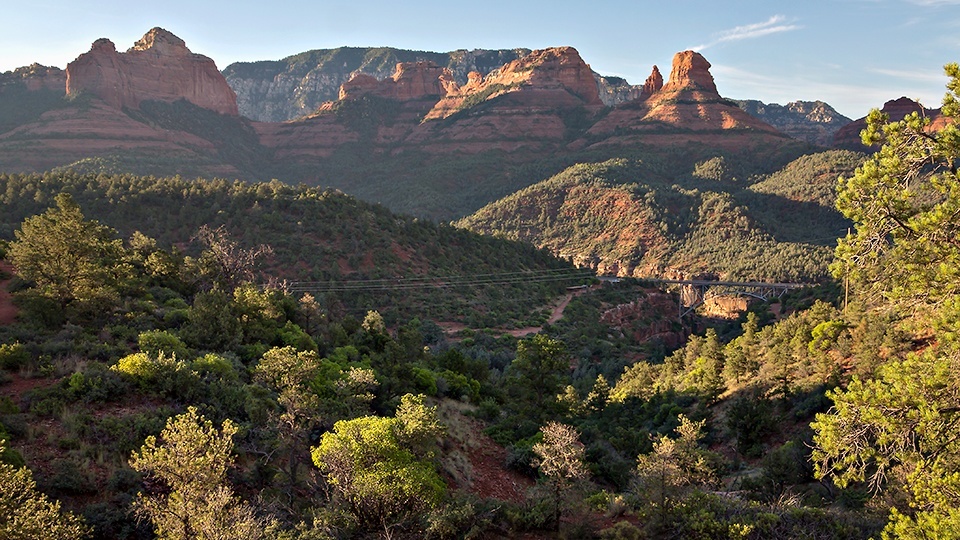
10 minutes, you’ll intersect the Jordan Trail. Veer left and begin the gradual ascent through Mormon Canyon. If you look up, you’ll see The Fin to your left. (On the way back, The Fin will be to your right.) Rising a mile above sea level, The Fin is one of many prominent rock formations that can be seen from the trail. Ship Rock (5,667 feet) and Steamboat Rock (5,228 feet) are two of the others.
While you’re looking around, you’ll notice two different colors of rock. The red layer is known as the Schnebly Hill formation. It was formed when ancient rivers deposited iron oxide from distant mountains. The white layer, the Coconino formation, comes from wind-blown sand that created dunes similar to those found in the Sahara Desert.
The rocks, of course, are what put Sedona on the map. And they’re the highlight of this trail, which, after 15 minutes, passes through a small gate. Although there are a lot of trees along the way, they’re not very tall. Therefore, there’s very little shade. That won’t be an issue this time of year — November is a great time to hike Sedona — but the sun will be out, so don’t forget to wear sunscreen.
Ten minutes beyond the gate, you’ll arrive at the western base of Steamboat Rock. If you’ve ever driven north through Oak Creek Canyon, you’ve seen this massive rock formation out the driver’s-side window. From the trail, you get a closer look. You’ll also see uptown Sedona to the south. And beyond that, Jerome and Mingus Mountain. As the trail winds around to the eastern side of Steamboat Rock, it reaches the high point (4,770 feet) of the hike, which follows an old road built by Jim Thompson to link his home in Oak Creek Canyon to Sedona.
The trail stays the same for about 15 minutes and then drops into Wilson Canyon. The trees become more prominent along this stretch, and the trail itself skirts the edge on its way down. Eventually, after an hour of hiking, you’ll arrive at an intersection with the Wilson Canyon Trail and the eastern boundary of the Red Rock-Secret Mountain Wilderness. If you have time, the short trail into the canyon is a good one that follows a small creek shaded by oaks and Arizona cypress trees.
Allow an hour or less for the detour. Otherwise, continue another 10 minutes to the trailhead at Midgley Bridge. It’s a busy place that’s used as a launch pad for a few other trails. It also serves as a rest stop for the masses making the scenic drive through Oak Creek Canyon (see page 52). Despite the congestion, it’s easy to see why Jim Thompson staked a claim just up the road. Even without a tropical sea, the views from both ends of this trail are pretty spectacular.
Length: 6 miles round-trip
Difficulty: Easy
Elevation: 4,503 to 4770 feet
Trailhead GPS: N 34˚53.286’, W 111˚46.097’
Directions: From the roundabout intersection of state routes 179 and 89A in Sedona, go north on SR 89A for 0.2 miles to Jordan Road. Turn left onto Jordan Road and continue 0.7 miles to Park Ridge Drive. Turn left onto Park Ridge Drive and continue 0.1 miles to where the pavement ends. From there, continue 0.5 miles on the dirt road that leads to the Jim Thompson Trailhead.
Special Consideration: A $5 day pass is required.
Vehicle Requirements: None
Dogs Allowed: Yes (on a leash)
Horses Allowed: Yes
USGS Maps: Munds Mountain, Wilson Mountain
Information: Red Rock Ranger District, 928-203-2900 or www.fs.usda.gov/coconino