
Ironwood Forest National Monument, Tucson
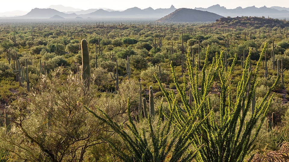
Desert ironwoods aren’t as iconic as saguaros, but the trees — officially known as Olneya tesota — are the unsung heroes of much of the Sonoran Desert. They can live for centuries in the scorching heat, they provide valuable shade for young saguaros and other desert flora, and their wood is among the hardest and densest in the world — hence the name. A drive through 190,000-acre Ironwood Forest National Monument offers plenty of these desert stalwarts, along with an up-close view of one of Southern Arizona’s most distinctive peaks.
From Marana along Interstate 10, head west on Marana Road. After passing through farmland and crossing the Santa Cruz River, you’ll turn right onto Silverbell Road and begin winding into the monument. The road eventually turns from pavement to dirt, but it’s well maintained and easy to navigate in most cars.
In addition to ironwoods — identified by their blue-green leaves, grayish bark and purple spring blooms — you’ll see paloverdes, saguaros, ocotillos and prickly pear cactuses, many of which are “nursed” by ironwoods. It’s an impressive contribution to the desert ecosystem, but ironwoods are impressive even after they die. Because their wood is so dense, it’s essentially immune to decay, so a dead ironwood might be around for several hundred years before it erodes away.
The plant life isn’t the only draw of this drive. The saguaros attract lesser long-nosed bats (a threatened species), and desert bighorn sheep live in the monument’s Silver Bell Mountains. Keep an eye out for hawks, roadrunners and turkey vultures, too. And the area’s human history is on display at more than 200 Hohokam rock art sites.
Soon, you’ll approach a mountain whose strange profile you’ve probably noticed while driving on I-10. Ragged Top, like ironwoods, is appropriately named. The rhyolite peak is a textbook example of a volcanic plug, which occurs when magma hardens in a vent on an active volcano. That’s what happened here about 22 million years ago. Today, Ragged Top is a popular climbing destination, but there’s no established trail to the summit. If you’re not in the mood for scrambling, just enjoy the views of the craggy peak from the road.
A couple of miles past Ragged Top, around Mile 20 of the drive, you’ll reach an intersection with Sasco Road. If you’re driving a passenger car or don’t feel like having your teeth rattled, turn around and head back to Marana the way you came. But if you have a high-clearance, four-wheel-drive vehicle, you can turn right and navigate a rocky, rutted dirt road to return to I-10 in Red Rock. The payoff on that road is views of Picacho Peak, the ghost town of Sasco and more ironwoods. But if you can’t do the whole drive, don’t worry. The ironwoods will be there the next time you visit — and a few hundred years after that, too.
Note: Mileages are approximate.
Length: 33 miles one way (from Interstate 10)
Directions: From Tucson, go northwest on Interstate 10 for 22 miles to Marana Road (Exit 236). Turn left (southwest) at the stop sign and continue 0.1 miles to Marana Road. Turn right onto Marana Road and continue 6 miles to Silverbell Road. Turn right onto Silverbell Road and continue 13.9 miles to Sasco Road. Turn right onto Sasco Road and continue 13 miles to Red Rock and I-10.
Vehicle requirements: None for Silverbell Road, but a high-clearance, four-wheel-drive vehicle is required for Sasco Road. Don’t attempt either portion of the drive if rain is in the forecast.
Warning: Back-road travel can be hazardous, so be aware of weather and road conditions. Carry plenty of water. Don’t travel alone, and let someone know where you are going and when you plan to return.
Information: Ironwood Forest National Monument, 520-258-7200 or www.blm.gov/arizona