
Canyon de Chelly National Monument, Navajo Nation
The easiest way to go back in time might be along the White House Ruins Trail. In just over a mile of moseying downhill, you go from the 21st century to sometime around A.D. 1060. As hikes go, this one won’t test your endurance, but the experience of descending into the canyon and eventually standing at the base of the ruins makes this trail one of the best trails in Arizona. Or anywhere else. In addition, it’s the only way to set foot in the canyon without a hired guide.
Although Canyon de Chelly is protected and managed as a national monument, all land within the park is Navajo tribal trust land, and approximately 40 Navajo families still live in the canyon. Thus the restrictions. However, because of the overlapping jurisdiction, hikers have a rare opportunity to glimpse a way of life that dates back several centuries. It’s time travel without warping the fabric of existence.
The adventure begins at an overlook that offers drive-by tourists a long-distance photo op of the prehistoric dwelling. There’s a sign there for the trail, but it can be a little confusing. The easiest thing to do is veer right and head for the flat rock. There’s no well-worn path to guide you, but there’s only one way to go. And as you go, you’ll get some remarkable views of the canyon.
After a few minutes, the flat rock leads to a tunnel flanked by some benches. This is where you’ll join the actual trail, which begins as a series of long switchbacks. The descent is steep, but not severe, and after about 10 minutes the trail narrows to a ledge. There’s a nice juniper along this stretch. Trees are rare in this national park, with the exception of down below, where clusters of old cottonwoods have been shading sheepherders for generations.
The downhill continues for another 10 minutes to a point where the trail enters a short, 40-yard tunnel. It’s more than hollowed-out rock, though. It’s where visitors transition from tourists on one side to honored guests on the other. It’s a rabbit hole into another world, one that’s been inhabited for nearly 5,000 years — no other place on the Colorado Plateau has been occupied longer.
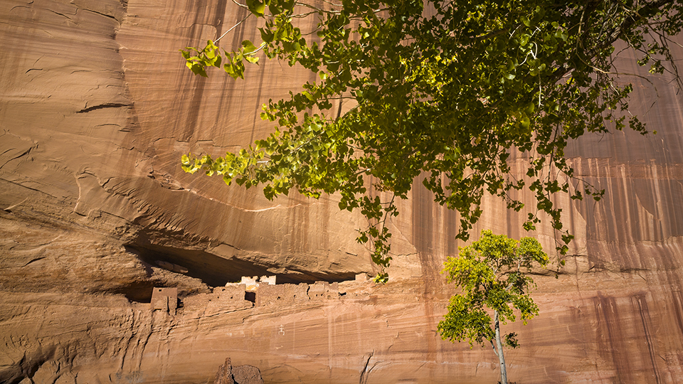
The Ancestral Puebloans, also known as Anasazis, showed up more than a thousand years ago — the canyons were ideal for raising crops. Initially, they built pit houses, which were replaced with more sophisticated homes as additional families migrated to the area. Eventually, homes were built in some of the canyon’s alcoves to take advantage of the sunlight and natural protection. White House Ruins is one of the most impressive, but it wasn’t enough to keep the Puebloans from moving on by the mid-1300s. After they were gone, the Hopis settled in. But they, too, moved on, making way for the arrival of the Navajo people, who continue raising sheep and corn in the canyon as they have for hundreds of years.
Back on the trail, just beyond the tunnel, you’ll get a close-up look at the Navajo presence. Ahead and to the right is a hogan, which is a traditional Navajo home. There’s a sign warning visitors that photography isn’t allowed. You’ll be tempted to pull out your camera, but please don’t. Instead, respect the wishes of your gracious hosts.
From the hogan, the trail turns to sand and quickly merges with a bridge that crosses a wash. In the vicinity, you’ll see four-wheel-drive tracks from the heavy-duty vehicles used by Navajo guides. You’ll also see what’s left of an old barbed-wire fence that parallels part of the trail. Trudging through the sand, you’d never know that 100 yards away is a place the Navajos call Kinii’ ni gai, which translates to “white house” — the name comes from the light-colored plaster on some of the rooms. Archaeologists believe that the settlement, built around A.D. 1060, may have had as many as 80 rooms and four kivas during its peak occupation. There’s less there now, but it’s still a fascinating glimpse back in time. And it’s the payoff on one of the best trails in Arizona.
Length: 2.73 miles round-trip
Difficulty: Easy
Elevation: 6,258 to 5,577 feet
Trailhead GPS: N 36˚07.827', W 109˚28.652'
Directions: From the visitors center at Canyon de Chelly National Monument, follow the South Rim Drive for 4.9 miles to the turnoff for White House Overlook. Turn left onto the park road and continue 0.5 miles to the trailhead.
Vehicle Requirements: None
Dogs Allowed: No
Horses Allowed: No
USGS Map: Canyon de Chelly
Information: Canyon de Chelly National Monument, 928-674-5500 or www.nps.gov/cach