
Pinal Mountains, Tonto National Forest
If you like trees, you’re going to love this trail. In the course of 6 miles and 3,000 feet, the progression goes something like this: manzanita bushes, piñon pines, alligator junipers, Gambel oaks, Arizona sycamores, Fremont cottonwoods, ponderosa pines, velvet ash, bigtooth maples, Engelmann spruce and quaking aspens. There aren’t many day hikes in Arizona — or anywhere else — with that much diversity. But you’ll have to earn the assorted look; this trek is almost entirely uphill. It’s not as grueling as Old Baldy or North Kaibab, but it’s demanding.
The hike begins at the Icehouse CCC Campground, which is one of several great reminders that the Civilian Conservation Corps spent significant time in the Pinal Mountains. The first quarter-mile or so winds through a thick stand of manzanitas and scrub oaks. After 10 minutes, you’ll arrive at a gathering of boulders. The rocks are big, the size of Kodiaks. Of course, there aren’t any real grizzlies in these mountains, but there are black bears, white-tailed deer, mountain lions, bobcats, coatimundis and a long list of others. Just beyond the boulders, the route intersects the Check Dam Trail, and a few minutes after that, it moves into a small grove of alligator junipers.
At the half-hour mark, Sixshooter crosses a rocky wash and cuts through a tunnel of manzanitas. This is where the uphill begins. Take a deep breath and a quick look at the long view of Globe to the north. At the end of the tunnel, the trail crosses Forest Road 112 and arrives at a steel gate. Much of this hike is in cattle country, and their lowing can be heard in the background. Unfortunately, you’ll notice their presence on the trail, too. Beware of the ubiquitous cow pies.
Past the gate, the trail enters a lush riparian area of cottonwoods and sycamores. Some of the trees are old, and some are just getting started. The first ponderosa is a few hundred yards away. It’s there that the trail begins its parallel with Sixshooter Canyon. Initially, it follows the east side, which is canopied by oaks, ponderosas and maples. The west slope is more exposed and dominated by high-desert vegetation. The combination adds up to the most beautiful stretch on the lower half of the hike.
Eventually, the trail crosses to the west side of the canyon, and then immediately back to the east. After that, it switches steeply uphill through a forest of pines where the ground is carpeted with needles. Although the end is a ways away, this area is a great place to stop and eat a Pop-Tart. Or at least slow down. From there, the switches continue for another hour to a point where the trail merges with an old, narrow jeep road. There, you’ll see your first spruce and get a glimpse of the towers atop Pinal Peak. The trail then drops steeply for 200 yards before turning uphill again.
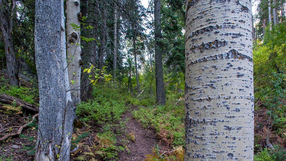
Fifteen minutes later, you’ll intersect the Telephone Trail, and shortly thereafter, you’ll see your first aspen. This is the steepest part of the trail, but also the most beautiful. Trudging along, you’ll pass an old mine shaft, which is difficult to spot on the way up but plainly obvious going the other direction. In the 1880s, an old cabin and sawmill were located in the vicinity of the mine. Sixshooter Canyon was allegedly named for the millworkers, who were partial to their revolvers.
Just beyond that bit of history is Ferndell Spring and an intersection with Trail 204. Keep straight on Sixshooter through a stand of very young aspens — about 2 inches in diameter. Five minutes later, you’ll cross Forest Road 651C, and a few hundred yards later, you’ll arrive at the Middle Trail, which is the turnaround point for this hike. If you love trees, you’re going to love this spot. The aspens are beautiful. So are the pines and maples and spruce. Trees ... that’s the nature of this trail.
Length: 12 miles round-trip
Difficulty: Strenuous
Elevation: 4,528 to 7,681 feet
Trailhead GPS: N 33˚19.587’, W 110˚48.274’
Directions: From U.S. Route 60 in Globe, go south on Hill Street (look for the Pinal Mountain Recreation Area sign near Milepost 251) for 0.2 miles to Broad Street. Turn right onto Broad Street and continue 1 block to Six Shooter Canyon Road. Turn left onto Six Shooter Canyon Road and continue 0.9 miles to Icehouse Canyon Road (just past Besh-Ba-Gowah Archaeological Park). Turn right onto Icehouse Canyon Road and continue 1.7 miles to a stop sign, where Icehouse Canyon Road becomes Forest Road 112. Continue south on FR 112, toward Pioneer Pass, for 2.4 miles to Forest Road 112A. Turn left onto FR 112A and continue 0.2 miles to the trailhead, which is located at the east end of the Icehouse CCC Campground parking lot.
Vehicle requirements: None
Dogs allowed: Yes (on a leash)
Horses allowed: Yes
USGS map: Pinal Peak
Information: Globe Ranger District, 928-402-6200 or www.fs.usda.gov/tonto