
Red Rock Ranger District, Sedona
Despite its name, this trail isn’t much of a secret. None of the hikes in and around Sedona are. Nonetheless, you’ll want to put Secret Canyon on your list. You probably won’t have it to yourself, but you might. That’s because of the 3.4 miles of dirt, sand and rocks between Dry Creek Road and the trailhead. There’s only one way to drive through it, and that’s with a high-clearance vehicle — four-wheel-drive is even better. The other option is to park at the front end of Forest Road 152 and ride a mountain bike to the trailhead. Either way, you’ll be glad you made the effort.
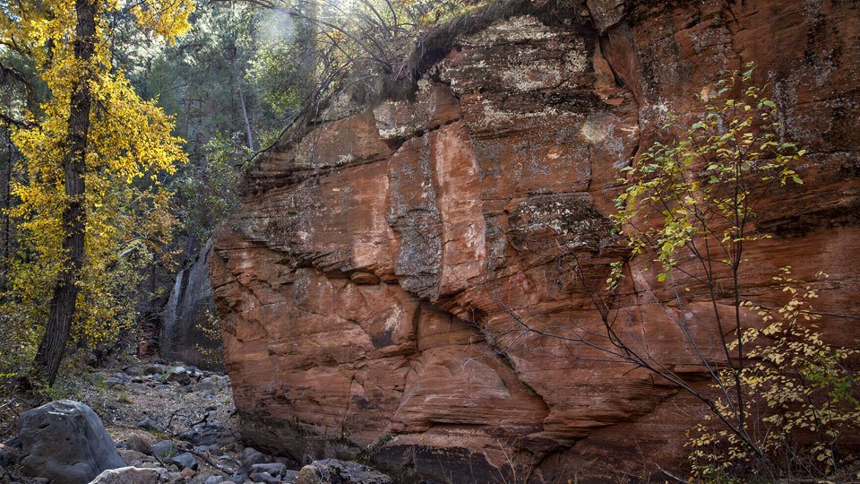
From the trailhead, the hike immediately crosses Dry Creek and arrives at the boundary of the Red Rock-Secret Mountain Wilderness, a 43,950-acre wonderland that’ll make you think: Holy moly. I can see why this place was given the world’s ultimate protection. Piñons, junipers, manzanitas and Arizona cypress are the dominant tree species in the early stages of the hike, but they’re overshadowed by the surrounding red rocks that epitomize the area. You’ll see a lot of iconic scenery in front of you on this hike, but every once in a while, it’s a good idea to do a three-sixty. The views are impressive, and that’s an understatement.
After 15 minutes, you’ll arrive at an intersection with the HS Canyon Trail, which veers left. From there, the footpath turns to a soft-packed red sand. It’s an ideal surface for hiking, but it doesn’t last long. Most of the route is a mix of rocks and dirt, with a lot of ground cover along the trail. In the summer, it gets pretty thick, but this time of year, it should look like fall.
Continuing northwest, the trail climbs gradually and arrives at a nice cluster of alligator junipers. In addition to the gators, you’ll get a glimpse of some tall trees growing from the side of a cliff to the left. It’s a hint of what’s to come when the trail transitions from piñons and junipers to pines and firs. But first, you’ll come to an intersection with the David Miller Trail, which splits to the right. Stay left for Secret Canyon.
From there, the trail drops about 100 yards and then climbs back up to a ridge before heading toward the canyon. Within 10 minutes, the route turns to pine needles and pine cones and arrives at a spot as beautiful as any. On this stretch, the trail skirts a sheer wall surrounded by Arizona sycamores, ponderosa pines and Douglas firs. This is the gateway to the canyon.
Continuing on, about an hour into the hike, the canyon narrows and the trail gets a little tricky to follow, especially in the summer, when a little bushwhacking is necessary. It’s less of a problem in November, but regardless of when you hike, common sense will guide the way.
The rest of the route stays about the same, with several creek crossings (don’t expect water) and a few scrambles up and down the various banks. Then, about 90 minutes in, you’ll start seeing some massive old-growth ponderosas, which shelter some equally impressive primitive campsites (if you backpack, mark the coordinates). At this point, you’ll be deep into Secret Canyon. Although there’s no obvious landmark to signal the end of the trail, you’ll know you’re there when you arrive at a deep ravine that cradles a series of pools. Another indicator is a massive flat rock, about the size of a boxing ring. It makes a great place to sit and enjoy the views. If you’re lucky, you’ll have it to yourself. If not, there’s room to spare.
Length: 11 miles round-trip
Difficulty: Moderate
Elevation: 4,684 to 5,097 feet
Trailhead GPS: N 34˚55.803’, W 111˚48.399’
Directions: From the roundabout intersection of State Route 179 and State Route 89A in Sedona, go southwest on SR 89A for approximately 3.1 miles to Dry Creek Road. Turn right onto Dry Creek Road and continue 1.9 miles to Forest Road 152 (Vultee Arch Road). Turn right onto FR 152 and continue 3.4 miles to the trailhead on the left.
Vehicle Requirements: A high-clearance vehicle is required.
Dogs Allowed: Yes
Horses Allowed: Yes
USGS Map: Wilson Mountain
Information: Red Rock Ranger District, 928-203-7500 or www.fs.usda.gov/coconino