
Imperial National Wildlife Refuge, Yuma
Depending on which poll you believe, 5 to 10 percent of Americans think the Apollo moon landings were a hoax. That observation might seem like an odd lede for a Scenic Drive, but as you head up Red Cloud Mine Road in the Imperial National Wildlife Refuge, north of Yuma, the reference makes more sense. The views along this rugged, isolated back road are a different kind of scenic: There’s almost no vegetation, and the rocky buttes could easily pass for a moonscape with a little 1960s-era color correction.
It’s enough to get the gears turning in any conspiracy theorist’s head, and the fact that the route passes through a U.S. Army proving ground might make you wonder whether there’s something here that someone doesn’t want you to see.
Or, if you’re among the other 90 to 95 percent of the country, you could just enjoy this 16-mile drive, which starts at Martinez Lake, a popular destination for birders, photographers and anglers. The lake was formed in 1935, when Imperial Dam, on the Colorado River, was completed. About a mile in, you’ll get a good view of the lake — the greenery surrounding it is a striking contrast with the surrounding desert.
After that, the road narrows and gets rougher, so take your time around corners and over medium-sized rocks. You’ll be hard-pressed to find cellphone service out here, and even in January, this isn’t a place you want to have car trouble. At Mile 5, you’ll pass the trailhead for the Painted Desert Trail, one of two designated hiking trails in the refuge.
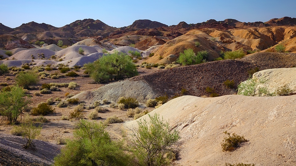
Shortly after that, the colors that give that trail its name — red, pink, yellow, black and several shades of brown — will begin to show themselves on the surrounding buttes. Once you enter the Army’s Yuma Proving Ground at Mile 7, you’ll start seeing signs warning you to avoid “unexploded ordnance.” It’s perfectly safe to pull over and make a few pictures, but don’t stray off the roadway.
Fourteen miles in, you’ll come upon perhaps the best views of the drive. Colorful buttes are everywhere as you descend into a small valley — you’re likely to see a hawk or two circling above. Just beyond there, you’ll see a small mining facility on your left. It’s the only significant sign of civilization on this route, and because Red Cloud Mine Road isn’t maintained beyond this point, it’s a good place to stop awhile before retracing your route back to Martinez Lake.
The alternative is to take along an all-terrain vehicle and continue north. If you do that, you’ll eventually end up in Cibola National Wildlife Refuge, which straddles the Arizona-California border. You could probably get there in a lunar rover, too. And who knows? There might be one from the Apollo missions stashed somewhere along the road.
Note: Mileages are approximate.
Length: 16 miles one way
Directions: From Yuma, go north on U.S. Route 95 for 24 miles to Martinez Lake Road. Turn left onto Martinez Lake Road and continue 10 miles to Red Cloud Mine Road. Turn right onto Red Cloud Mine Road and continue 16 miles before retracing your route back to Yuma.
Vehicle requirements: A high-clearance, four-wheel-drive vehicle is required.
Information: Imperial National Wildlife Refuge, 928-783-3371 or www.fws.gov/southwest/refuges
Travelers in Arizona can visit www.az511.gov or dial 511 to get information on road closures, construction, delays, weather and more.