
North Kaibab Ranger District, Kaibab Plateau
There isn’t a pot of gold at the end of this trail, but there’s something more impressive: the Grand Canyon. Despite the visual impact of a pile of money, the views from this remote trail are even better. They’re priceless, and they’re unlike anything you’ll see in the national park or on postcards or in coffee-table books featuring photos of the most beautiful places on Earth. Holy cow, holy moly, holy ... the views are out of this world.
In all, the trail runs for 18 miles from Timp Point on the south end to Parissa-wampitts Point up north. Those are two of the five major points that jut into the Canyon from the western edge of the Kaibab Plateau. The other three are Fence, Locust and North Timp. With a car-shuttle system or an overnight backpack, hiking all 18 miles is the way to go, but for a simple day hike, it’s hard to beat the southernmost segment, from Timp Point to North Timp Point.
The hike begins at a scenic overlook that’ll make you think twice about hitting the trail. Why would I ever leave this place? you’ll wonder. You’ll wonder the same thing at North Timp Point, but first you’ll have to get there, and that’s hardly a hardship. Within the first 60 seconds, the route makes a 90-degree turn away from the Canyon. It’s counter-intuitive, but that’s the nature of the Rainbow Rim Trail. It winds in and around a series of small, steep side canyons, and it never seems to be headed toward its namesake rim. Eventually, however, it gets there.
The trees at the outset are mostly ponderosas, and some of them have been tickled by fire. The black marks are obvious, but they’re nothing like the fire damage you’ll drive through on parts of the North Rim Parkway.
After about 10 minutes, the trail veers north, then east through an open forest to a pair of giant, old-growth ponderosas. The first aspen shows up a few minutes later on the ridge of one of the side canyons.
The canyons, which are a constant along the way, make this trail a lot longer than the straight-line distance between Timp and North Timp points. Napoleon would have built bridges. You’ll take the scenic route, which continues downhill to the bottom of a gully that’s verdant and damp — by Arizona standards — and thick with old-growth trees.
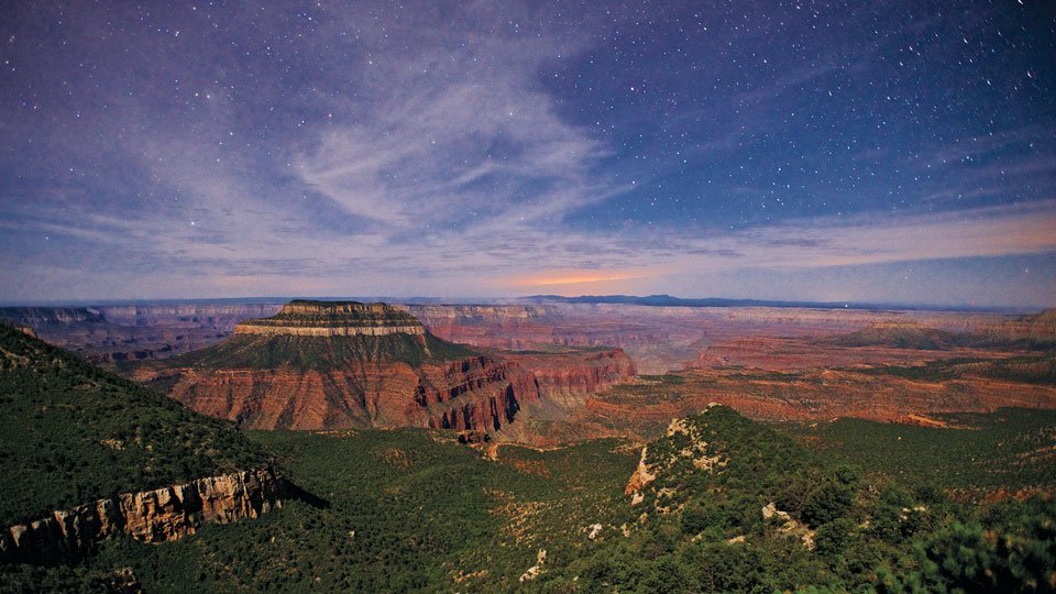
From the gully, the trail zigzags uphill and then makes a beeline for the rim of the Canyon. There you’ll see an incredible panorama that includes Timp Point (to the left), the Powell Plateau, Steamboat Mountain, Great Thumb Mesa and Tapeats Amphitheater, as well as the Mount Trumbull Wilderness to the northwest. It’s only a tease, however, because the trail quickly dips back into the forest, which has enough openings in its canopy to allow for some grassy areas below. Look for Kaibab squirrels in the old trees and mule deer all around. There are mountain lions in the area, too, and they like to eat the mule deer. You probably won’t see any of the big cats, but you might come upon one of their kill sites. If you do, don’t linger. Although pumas rarely attack human beings, there are exceptions to that rule, and they definitely don’t like sharing their food. Be smart, and be aware of their presence. That’s the point.
The rest of the route continues through the woods and, after about an hour, arrives at North Timp Point. If you’re lucky, you have a second SUV parked at Locust Point, Fence Point or Parissawampitts Point. If not, this is your turnaround, but you’ll want to hang out at North Timp for a while. Of the rim’s five scenic viewpoints, this one is the best. It’s Mother Nature’s version of a pile of money.
Length: 6 miles round-trip (Timp Point to North Timp Point)
Difficulty: Easy
Elevation: 7,611 to 7,657 feet
Trailhead GPS: N 36˚22.913’, W 112˚21.379’
Directions: From Jacob Lake, drive south on State Route 67 for 26 miles to Forest Road 22. Turn right onto FR 22 and drive 10.4 miles to Forest Road 206. Turn left onto FR 206 and drive 4.9 miles to Forest Road 271. Veer left onto FR 271 and continue 7.9 miles to the trailhead at Timp Point.
Vehicle Requirements: A high-clearance vehicle is recommended.
Dogs Allowed: Yes (on a leash)
Horses Allowed: Yes
USGS Map: Timp Point
Information: North Kaibab Ranger District, 928-643-7395 or www.fs.usda.gov/kaibab