
Coconino National Forest, Sedona
Two point nine miles. That’s what separates two of the most disparate hiking experiences in Arizona. On one end is West Fork, the busiest trail on the Coconino National Forest. A few miles to the north is Pumphouse Wash. Although both routes wind through narrow canyons that are bursting with natural beauty, the first is usually crowded with inexperienced hikers who take advantage of the easy trailhead access and the undemanding tiptoe along the creek. Pumphouse Wash is the opposite. There aren’t any crowds, there isn’t a trail, and parking is hard to come by. In fact, there’s only one parking spot. And the only way to reach it is to drive south from Flagstaff on State Route 89A — the spot is located on the right-hand side of the road at the bottom of the switchbacks, just before you get to the bridge that crosses the wash.
If you can get the spot, great. Otherwise, the best bet is to grab one of the parking spots near the entrance to Pine Flat Campground, which is three-quarters of a mile south of the bridge. Wherever you park, use extreme caution when getting into and out of your car. The road is narrow, the shoulders are narrow, and the speed limit is often ignored. Also, remember that it’s best to walk against oncoming traffic. Admittedly, parking is a fuss, but Pumphouse Wash is worth the effort. Especially this time of year.
The “trail” begins on the north side of the bridge. From that lone parking spot, you’ll see a narrow track that drops steeply down to the wash. When you get to the bottom, turn left and start looking for the path of least resistance. For the next couple of hours, that’ll be your
mission as you scramble among the boulders that Mother Nature has scattered on the canyon floor.
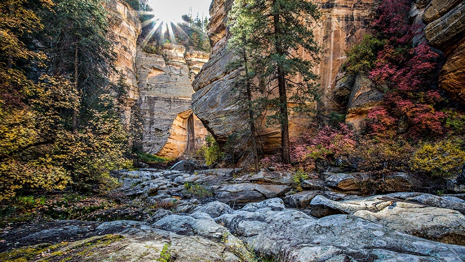
Although there isn’t an actual trail, it’s just about impossible to get lost — all you have to do is stay between the steep canyon walls. Heading east, you’ll immediately pass beneath the bridge. As you look around, you’ll see why the effort to get there was worthwhile. The red rocks are wallpapered with pines and spruce, Arizona sycamores grow among the rocks, and Gambel oaks are in between. But for all the trees, it’s the boulders that command your attention, which range in size from toaster ovens to Smart cars. And maneuvering them can be a challenge. Or an adventure, depending on your disposition.
As a general rule, there aren’t any wrong headings, but once in a while you’ll find yourself on rock that’s too high to jump from. When that happens, you backtrack and find another route. The most important thing is that you watch your step — the rocks in there are determined to get your ankles.
After about 10 minutes of hiking, the canyon veers right. And five minutes later, it narrows to about 30 feet. Look for an ancient ponderosa log that’s been jammed in the opening for who knows how long. It was likely delivered by rushing floodwaters, which brings up another disclaimer: Never hike in narrow canyons when storms are possible. In this particular canyon, the risk is greatest during the monsoon, but even in October, an unexpected storm can move in. As always, pack a thinking cap when you’re headed into the wilderness.
Moving along, you’ll come to another narrow passage, one that zigs and zags through the rocks. That’s followed by yet another slot, one that squeezes to a width of only 12 feet. It’s here that you might start seeing water. Unlike the West Fork of Oak Creek, which is a year-round stream, the water in this canyon is usually in the form of deep pools. Unfortunately, you won’t know how deep, which means you’ll have to go around. In most cases, there are rock benches on either side that can be used for the portage.
Once you make your way around the water, you’ll be back among the boulders. Keep in mind that any rock can roll. Even the biggest rocks. And, ironically, hiking poles don’t really help on this trek. They don’t stick in rock, and you’ll need both hands to catch yourself when you lose your footing. And you will.
About 45 minutes in, you’ll come to the longest passage of the day. From one end to the other, it’s about 50 yards. Beyond it, the climb gets a little steeper. And it gets technical, too. The first obstacle is an 8-foot climb into a hollowed-out section of rock. It’s not especially difficult, but if you’re not used to climbing, this is probably a good place to turn around. If you’re not intimidated, hop up and keep going.
Within a few minutes you’ll see a big water hole ahead. And then another and another. In each case, there’s a bench to the right. But even on those, you need to be careful. Their width varies, and there can be loose rock in places. Keep using that thinking cap, and, after about an hour of overall hiking, you’ll come to the biggest pool yet. Although it’s possible to bushwhack around it, and backpackers do, this is the place for day hikers to turn around. But don’t be in a hurry to get back to your car. Instead, string a hammock and enjoy the solitude. Chances are, you’ll have the place all to yourself. That almost never happens on West Fork.
Note: Mileages are approximate.
Length: 3.5 miles round-trip
Difficulty: Moderate
Elevation: 5,725 to 6,077 feet
Trailhead GPS: N 35˚01.504', W 111˚44.197'
Directions: From the roundabout intersection of State Route 179 and State Route 89A in Sedona, go north on SR 89A for 12.5 miles to Pine Flat Campground and take one of the parking spots along the road.
Vehicle Requirements: None
Dogs Allowed: Yes (on a leash)
Horses Allowed: No
USGS Map: Mountainaire
Information: Red Rock Ranger District, 928-203-2900 or www.fs.usda.gov/coconino