
Buenos Aires National Wildlife Refuge, Southern Arizona
Some of Arizona’s roads are deceptively named. Take Rural Road in the Phoenix area, for example. If you’ve driven it in the past half-century or so, you know there’s no longer anything rural about it. But Pronghorn Drive isn’t one of those roads. It’s a scenic 10-mile loop at Buenos Aires National Wildlife Refuge in Southern Arizona, and it offers a chance to see its namesake ungulates, plus rare birds, rolling grasslands and an iconic peak.
Of course, just because the pronghorns are there doesn’t mean you’ll actually see them. They’re fast — over short distances, they can hit 55 mph. You’ll be going considerably slower than that, both to avoid startling the herds and because Pronghorn Drive is a little rough in parts. In good weather, though, you can do this drive in a Prius. Just tread lightly.
From the refuge’s entrance road off State Route 286, follow the signs to Pronghorn Drive. You’ll then come to a “Y” intersection. You can drive the loop in either direction, but if you’re following along here, bear right to go counter-clockwise. You’ll quickly see what makes the 117,000-acre refuge so special. Formerly a cattle ranch, it’s been meticulously restored to its original state as a semi-desert grassland and a haven for hundreds of animal species. They include the endangered masked bobwhite, a quail species so rare that if you see one, you should report it to the refuge’s visitors center.
A mile and a half into the drive, the road curves to the left, offering a good view of Baboquivari Peak. The unmistakable mountain has its own wilderness area (the smallest one in Arizona) and is the most sacred site for the Tohono O’odham people, whose tribal land lies just to the west. To the northeast are the Las Guijas Mountains, which form part of the refuge’s eastern border.
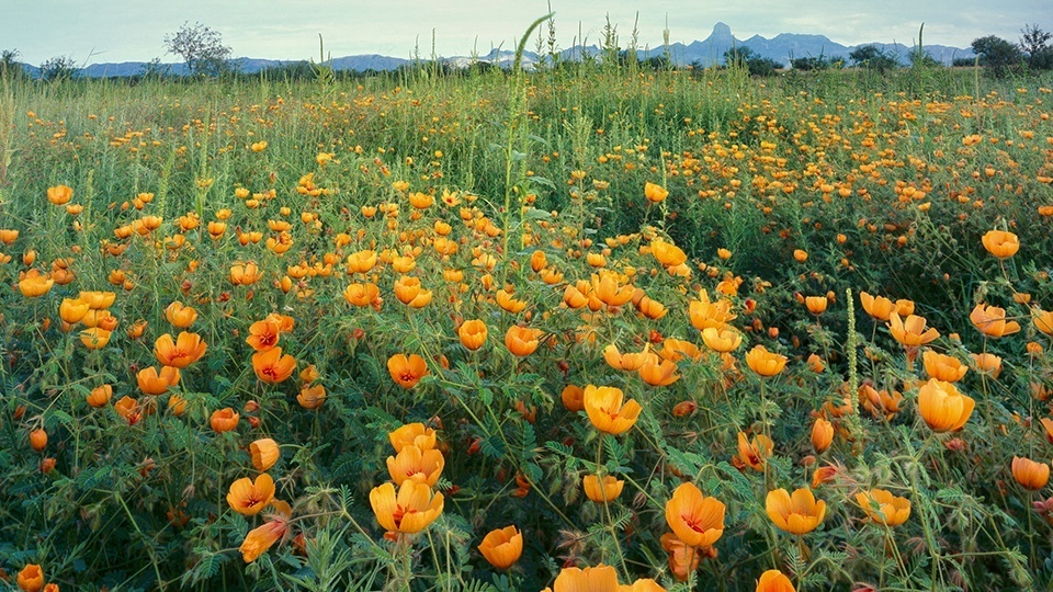
If you haven’t spotted a pronghorn yet, there’s plenty more to see as you roll over the low hills. Mule deer are plentiful in the refuge, and more than 330 bird species have been documented there. Among the high grasses, you might spot a black-throated sparrow, a northern cardinal or a Chihuahuan raven, just for starters. And in spring, the area comes alive with wildflowers.
Eventually, the loop curves to the northwest and heads back toward where you started. This stretch offers good views of the Altar Valley, into which you’re descending. Keep an eye out for wildlife, or just enjoy the tall grasses, which undulate hypnotically in a good breeze. When you finish the drive, if you’re so inclined, you can stop by the visitors center to pick up a map or find a hiking trail. If you packed a lunch, you can enjoy it at one of the picnic tables overlooking the valley. Maybe a pronghorn will stop by to say hello.
Note: Mileages are approximate.
Length: 10-mile loop (from refuge entrance road)
Directions: From the intersection of State Route 86 (Ajo Way) and Interstate 19 in Tucson, go west on SR 86 for 21 miles to State Route 286. Turn left onto SR 286 and continue 38 miles to the Buenos Aires National Wildlife Refuge entrance road. Turn left onto the entrance road and continue 2.1 miles to Pronghorn Drive. Turn right onto Pronghorn Drive and continue 0.1 miles to a “Y” intersection. Bear right to stay on Pronghorn Drive, then continue 9.9 miles around the loop and back to the entrance road.
Vehicle requirements: A high-clearance vehicle is recommended, but the loop is passable in a standard sedan.
Special consideration: The refuge’s visitors center is open from 9 a.m. to 4 p.m. Tuesdays through Saturdays from November through April, but call ahead, as the hours sometimes change. There is no fee to visit the refuge.
Warning: Back-road travel can be hazardous, so be aware of weather and road conditions. Carry plenty of water. Don’t travel alone, and let someone know where you are going and when you plan to return.
Information: Buenos Aires National Wildlife Refuge, 520-823-4251 or www.fws.gov/refuge/buenos_aires