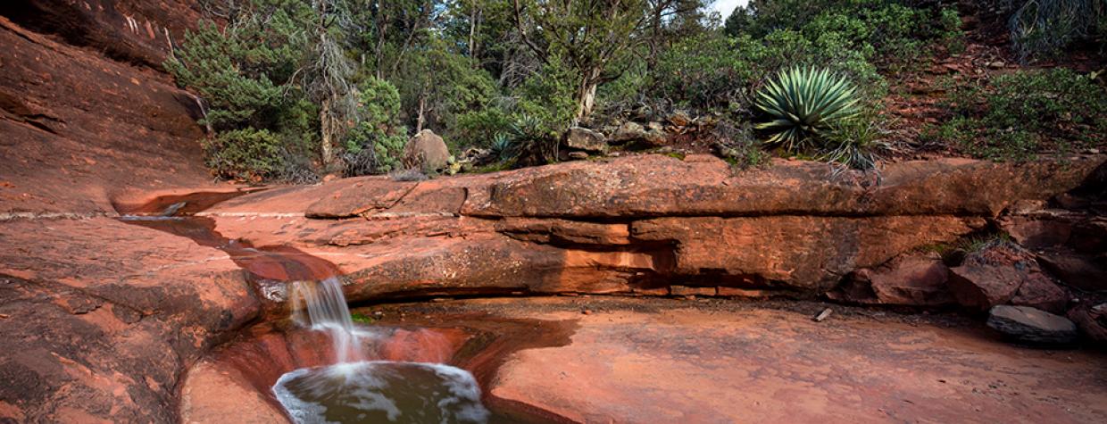
Coconino National Forest, Sedona
On paper, Schnebly Hill Road is an irresistible temptation. Like the fire-roasted corn at Elote Café. The description: “Twelve miles of dirt road, winding through the red rocks of Sedona, with spectacular panoramas.” It sounds like a leisurely Sunday drive. However, unless you drive a light tank with the turning radius of a Big Wheel and the off-road mobility of a dune buggy, it’s not so relaxing. Too rugged. That’s why it’s best to steer clear and hike the adjacent trail instead. Turns out, the Munds Wagon Trail winds through the same red rocks, with the same vistas, but without the risk of ripping off your muffler.
The hike begins at the lower end of Schnebly Hill Road, at a well-developed trailhead that also serves as a starting point for the Huckaby Trail and the Margs Draw Trail. You can make it there in a Fiat, but the lot fills up when the weather’s nice. And, sometimes, even when it’s not.
From the trailhead, the route drops into a wash. It’s a short descent marked by flood-resistant cairns in wire cages as tall as TV trays. The locals describe Sedona trails as being “red velvet,” because there’s no dust. You’ll see that on this route.
About five minutes in, the trail veers left and parallels Schnebly Hill Road, which makes frequent appearances. The road itself is benign, but it does serve as a thoroughfare for some of the local jeep tour companies. Instead of an annoyance, though, the jeeps serve as a reminder that hiking is the way to go, especially in the spring, or during the monsoon, when the trail gets a little splashy with all of its waterfalls. If you can time it right, the running water makes this trail hard to beat. But even without it, it’s on the A-list.
After crossing the road a second time, the trail drops into Bear Wallow Canyon. It’s unlikely you’ll see a bear, but you will see an escalation of trees, mostly junipers. Before long, the trail hits the bottom of the drainage and passes a gnarly, old alligator juniper — one of the many elders along the way. Just beyond the venerable evergreen, you’ll come to a lovely grove with three or four picnic tables. You won’t be tired yet, but it’s a good place for lunch on the way back.
Ten minutes later, the trail intersects the Hangover Trail, the etymology of which makes you wonder. Veer right and continue toward the creek bed. From there, the trail pushes out of the canopy and then back in before arriving at an “equestrian bypass.” Here, the horses go right and the hikers go left. That’s unfortunate for those on horseback, because the slick-rock they’re being protected against is arguably the most interesting part of the trail.
When the waterfalls are running, it’s a scene from a Zane Grey novel. And it’s easy to imagine the history of the trail, which was used in the late 1800s by a rancher named Jim Munds, who would drive his cattle from the Verde Valley up to the pastures near present-day Munds Park. Later, in 1902, J.J. Thompson, with funding from Coconino County and help from fruit growers and ranchers in Sedona and Oak Creek Canyon, improved the cattle track and opened it to wagon use. Later still, in the 1930s, Schnebly Hill Road was built and the Munds Wagon Route became obsolete — it literally faded into the forest. Fortunately, the original wagon trail was rediscovered by some forest rangers, who resurrected the route.
Continuing along, about an hour in, the trail begins to climb. First a zig, then a zag. Then another crossing of the road, and then an intersection with a trail to the “cow pies,” a cluster of rocks appropriately named. Before long, the trail breaks out of the canopy again and offers some amazing views of Mitten Ridge to the west and Munds Mountain to the east.
After a brief slog in the open air, the trail dips back into the trees and winds around Merry-Go-Round Rock. The grade levels off a little at this point as the trail makes a final run to its northern trailhead on Schnebly Hill Road. When you get there, you’ll see why the road is so tempting as a scenic drive. However, you might also see a Subaru go by with its tailpipe scraping the ground.
Length: 8.5 miles round-trip
Difficulty: Strenuous
Elevation: 4,454 to 5,525 feet
Trailhead GPS: N 34˚52.002', W 111˚44.915'
Directions: From the roundabout intersection of State Route 179 and State Route 89A in Sedona, go south on SR 179 for 0.3 miles to Schnebly Hill Road. Turn left onto Schnebly Hill Road and continue 0.8 miles to the trailhead on the left.
Special Consideration: A $5 day pass is required.
Vehicle Requirements: None
Dogs Allowed: Yes
Horses Allowed: Yes
USGS Maps: Sedona, Munds Park, Munds Mountain
Information: Red Rock Ranger District, 928-203-2900 or www.fs.usda.gov/coconino

