
Harquahala Mountains, near Wickenburg
The average 5-year-old, it’s been said, asks about 400 questions per day. But you can double that number by taking your child up Harquahala Mountain. I learn this when my son, Westley, comes along on my Arizona Highways assignment. As we tackle this rugged, challenging 10.5-mile drive, I hear queries that include: “How much farther?” “Is it always going to be this bumpy?” and “What if we get a flat tire?”
The answers, in order: It’s farther, OK? Yes, it is, apparently. And … well, let’s just not get a flat tire. This drive isn’t for the faint of heart. You’ll need a sturdy vehicle, four-wheel-drive, a light accelerator foot and a heavy dose of patience. But your reward is expansive views from the highest peak in Southwestern Arizona.
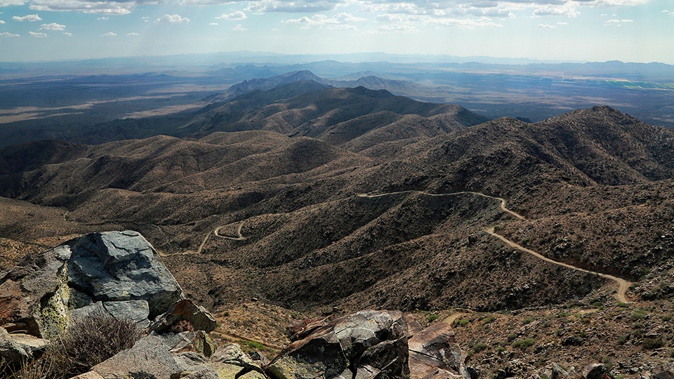
We begin on Eagle Eye Road, which runs south from the small community of Aguila, west of Wickenburg, to a point near Interstate 10 west of Phoenix. We turn onto the Harquahala Mountain Back Country Byway, a narrow, unmaintained and deeply rutted route that climbs the southern face of the Harquahala Mountains.
Just after the turnoff is a staging area where visitors can get information about the region. Saguaros, ocotillos, teddy bear chollas and other desert plants dot the landscape as we begin rolling over the road’s dips and washes. “Why don’t they pave this road?” Wes asks. The biggest reason is probably that not many people use it. In fact, when we make the trip on a Friday morning, the only other vehicles we see are at a campground a couple of miles in.
We quickly find that “slow and steady” is our only option. In some sections, softball-sized rocks litter the road, and we don’t want to hit those at full speed. But those sections are interspersed with smoother areas that give our suspension a break. In the calmer areas, Wes and I discuss the difference between two-wheel-drive and four-wheel-drive — along with the flat-tire possibility, which I assure him is “a grown-up problem.”
Before long, we’re climbing a long series of switchbacks. Here, my attention is firmly on the road, as it has to be. There are no guardrails, and if we veer off the path, it’s a long way down. A handful of pullouts offer views of the Kofa Mountains to the south and the Lower Colorado River Valley to the west. The final mile before the top is particularly challenging, ascending more than 1,400 feet, but we navigate it without much trouble and reach the summit about an hour after starting the drive.
Atop 5,620-foot Harquahala Mountain is an abandoned astrophysical observatory, built by the Smithsonian Institution in the 1920s to measure solar activity. It’s listed on the National Register of Historic Places. There’s also a modern Central Arizona Project facility that’s used to manage the canals running from the Colorado River. And there’s the boundary of the Harquahala Mountains Wilderness, which is home to rare cactuses and desert bighorn sheep.
Before heading down, Wes and I explore the summit and enjoy the views to the horizon in all directions. The return journey requires just as much patience, but at least gravity is on our side now. As we pull back onto Eagle Eye Road, Wes asks one more question: “Dad, did you know it was going to be like that?” No, I didn’t. And sometimes, that’s what makes it interesting.
Note: Mileages are approximate.
Length: 10.5 miles one way (from Eagle Eye Road)
Directions: From Wickenburg, go west on U.S. Route 60 for 26.5 miles to Eagle Eye Road in Aguila. Turn left (south) onto Eagle Eye Road and continue 18.5 miles to the Harquahala Mountain Back Country Byway (Bureau of Land Management Road 9300). Turn right onto the byway and continue 10.5 miles to the summit of Harquahala Mountain.
Vehicle requirements: A high-clearance, four-wheel-drive vehicle is required.
Warning: Back-road travel can be hazardous, so be aware of weather and road conditions. Carry plenty of water. Don’t travel alone, and let someone know where you are going and when you plan to return.
Information: Hassayampa Field Office, 623-580-5500 or www.blm.gov/arizona