
Coconino National Forest, Payson
Fred Haught was a relative of Anderson Lee Haught, who was better known as “Babe,” a longtime hunting guide for Zane Grey. All three men left their marks on the Mogollon Rim. Although the writer fled Arizona in a huff, the Haught boys stuck around and had a couple of trails named in their honor. The Babe Haught Trail is a short hike that begins near Knoll Lake, and the Fred Haught Trail is a long haul that ranks as one of the best routes in Arizona, especially in late summer, when the monsoon rains feed the ferns, wildflowers and perennial grasses.
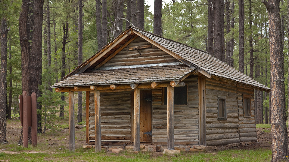
The hike begins at the General Springs Cabin, which is one of several Rim cabins built in the early 1900s by the U.S. Forest Service. Today, the cabins (General Springs, Pinchot and the Buck Springs Fire Guard Station) are connected by what’s known as the Cabin Loop Trail System. Fred Haught is part of that network. It’s a quiet place now, but in 1882, a few decades before the cabins were built, the area was the site of the last major battle between the U.S. Army and the Apaches. In all, more than 20 Apache warriors died, along with two U.S. soldiers. You’ll pass a memorial to the Battle of Big Dry Wash, erected in the 1930s by the Civilian Conservation Corps, as you approach the trailhead.
From there, the hike heads north through a beautiful woodland of ponderosa pines and broad ferns, and past a high fence that keeps elk from feasting on a revegetation area. For the first half of the outbound to Pinchot Cabin, Fred Haught overlaps a segment of the Arizona Trail — it’s well marked and easy to follow. About 10 minutes in, the sandy dirt track drops to the bottom of General Springs Canyon, climbs the east bank, and then drops back down to the creek. There, you’ll cross over to the west side. In addition to the trees and lush ground cover, this stretch is punctuated by rocky cliffs on either side — as if Fred Haught didn’t have enough going for it already.
Continuing on, the canopy eventually opens up and the canyon gets wider. Unless the drought completely wipes out the summer rains, there should be water in the creek, which you’ll cross several times. After about an hour of hiking, the Arizona Trail splits off and heads west. Veer right to keep on the Fred Haught Trail, which sticks with the creek and winds to the northeast.
A quick note about Fred Haught: Officially, it’s Trail No. 141, but there are still signs in the woods, relics from the past, that mark it as Trail No. 22. Don’t be confused. Just keep your eyes peeled for the “Cabin Loop” markers and you’ll be OK.
A few minutes beyond the split, you’ll come to Fred Haught Spring and a half-mile spur that leads to the Fred Haught Cabin. If you have the time, it’s a worthy side trip. Otherwise, carry on as the trail begins a slight ascent, crosses a narrow forest road and arrives at the head of Quien Sabe Draw. Although this trail can be done as a day hike, it’s ideal for backpacking, too, and this spot makes a great place to pitch a tent.
From there, the trail follows an old jeep road down into the draw. Twenty minutes later, it veers east out of the draw and into a smaller wash. There’s a slight ascent as you make your way past Quien Sabe Spring to Fred Haught Ridge. The trail then crosses Forest Road 95 before descending to the edge of Bear Canyon, where, as unlikely as it seems, you’ll come to FR 95. Again. This is the only tricky spot on the trail. There’s no clear indication that you need to turn right onto the road, but that’s the route. You follow the road around the steep banks of the canyon for a few hundred yards to where the trail resumes at an embankment that leads into the woods. Look for the “Cabin Loop” marker.
At the top of the rise, the trail crosses Forest Road 139A and makes a downhill run to the northern trailhead at Pinchot Cabin. It’s a beautiful, parklike setting, one that belies the violent history of 1882. As you sit there catching your breath and eating your lunch, you’ll understand why the Haught boys sank their roots in this hallowed ground.
Length: 13.25 miles round-trip
Difficulty: Moderate
Elevation: 7,263 to 6,975 feet
Trailhead GPS: N 34˚27.553', W 111˚15.048'
Directions: From Payson, go north on State Route 87 for 28.5 miles to Forest Road 300. Turn right onto FR 300 and continue 12.1 miles to Forest Road 705 (look for a historical marker for the Battle of Big Dry Wash). Turn left onto FR 705 and continue 0.3 miles to General Springs Cabin. The road veers right at the cabin and leads to a small parking area and the trailhead.
Vehicle Requirements: A high-clearance vehicle is recommended.
Dogs Allowed: Yes
Horses Allowed: Yes
USGS Maps: Dane Canyon, Blue Ridge Reservoir
Information: Mogollon Rim Ranger District, 928-477-2225 or www.fs.usda.gov/coconino