
Prescott National Forest
There are 90 wilderness areas in Arizona. And within their boundaries are 4.5 million acres of “earth untrammeled by man.” That definition comes from the Wilderness Act, which ultimately protected some of the most beautiful places in the United States, including a piñon-juniper woodland northwest of Prescott. Although the Apache Creek Wilderness accounts for only 0.1 percent of the total wilderness area in Arizona, it’s every bit as worthy of that crucial designation.
Established in 1984, the 5,633-acre wilderness is anchored by rolling hills that shelter a variety of trees and wildlife, outcroppings of granite boulders, three natural springs and several important riparian areas. And despite its rugged nature, the area is relatively accessible — only the last mile of forest road gets tricky. What’s more, the route that leads to the wilderness passes the Walnut Creek Center for Education and Research, which offers a variety of education and volunteer opportunities. It’s worth a visit, either before or after the hike.
Like many loops, the Apache Creek Loop is a combination of trails. Each has its own name, but they’re distinguished in the forest by their numbers, so you’ll want to make note of those. The first trail, hiking counterclockwise, is Trail 9904 (Graber Wash Trail). Within a few minutes of the trailhead, you’ll arrive at the trail register. Don’t be alarmed if it’s been a week or two since anyone has signed in. This loop doesn’t get a lot of traffic.
From the register, the trail begins a slight downhill on a rocky path through a wooded area of piñons and manzanitas. In the distance, to the north, you’ll catch glimpses of Juniper Mesa. After 20 minutes, the trail dips into a wash that feeds two massive alligator junipers, the first of many, as well as a few ponderosa pines. Ten minutes later, you’ll pass some ancient cottonwoods and arrive at Apache Creek, which is the one place that can get confusing. Although this loop features dozens of well-placed cairns — hats off to the team at the Chino Valley Ranger District — there aren’t any cairns to direct hikers across the creek. Instead, the trail dead-ends about 100 feet beyond the obvious crossing point. If you miss the turn, backtrack and rock-hop across the water.
Once you’ve crossed, and climbed the bank on the other side, you might have to bushwhack through some tall thistles. The trail is faint, but keep pushing and you’ll eventually see the next series of cairns, which lead across a wide meadow to an intersection with Trail 9905 (Apache Creek Trail). A minute or two later, the route crosses into the wilderness area.
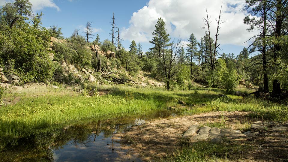
As the name suggests, the second trail follows the creek, and of the four legs, it’s the best. The lush vegetation and perennial stream support an array of wildlife, including mule deer, elk, jackrabbits, hooded skunks, bobcats, ringtails, mountain lions, gray foxes and black bears. Decades ago, there were even grizzlies along the creek. Keep your eyes peeled. And your ears — because of the thickets, the sound of cracking branches might be all you get.
Heading southwest, the trail follows a low ridge that looks down on the creek. Then, about an hour in, you’ll cross the creek in what is arguably the prettiest spot on the loop. Enjoy the riparian nature of things, and start looking to the left for a good-sized cairn across a small meadow. This is another tricky spot, but nothing like the first creek crossing. Ten minutes later, you’ll come to an old corral — you’ll likely see cattle on this trail in the spring — along a grassy floodplain ringed by some impressive ponderosas. A few hundred yards later, you’ll arrive at an intersection with Trail 9906 (Upper Graber Wash Trail).
Veer left and continue uphill for about a mile to Forest Road 95A. You might see some turkeys along the way. When you get to the forest road, which is too rugged for most vehicles, turn left to complete the loop. Although the final leg isn’t “earth untrammeled by man,” the surrounding landscape is beautiful, the narrow road is easy to follow, and, in the spirit of wilderness, there’s a good chance you’ll have the home stretch all to yourself.
Length: 6.1 miles round-trip
Difficulty: Easy
Elevation: 5,471 to 5,234 feet
Trailhead GPS: N 34˚53.964', W 112˚51.690'
Directions: From Prescott, go north on Williamson Valley Road for 35.7 miles to County Road 125 (after 22 miles, the road turns to dirt). Turn left onto CR 125 and continue 1.8 miles to Forest Road 95. Turn left onto FR 95 and continue 1.2 miles to Forest Road 95A. Turn right onto FR 95A and continue 1.2 miles to the trailhead for Trail 9904 on the right. Because there is no established parking area at the trailhead, it is recommended that you park at the gate that’s located 0.2 miles before the trailhead.
Vehicle Requirements: A high-clearance vehicle is required; four-wheel-drive is recommended for Forest Road 95A.
Dogs Allowed: Yes (on a leash)
Horses Allowed: Yes
USGS Maps: Camp Wood, Indian Peak, Juniper Mountains
Information: Chino Valley Ranger District, 928-777-2200 or www.fs.usda.gov/prescott; Walnut Creek Center for Education and Research, 928-445-3831