
Madera Canyon, Coronado National Forest
The drive from Green Valley to Vail, with a side trip into Madera Canyon, winds into and around the Santa Rita Mountains of Southern Arizona. Inhabited for thousands of years and rich in lumber and mineral deposits, the area is as alive with history as it is famed for its biodiversity. Pack a lunch and plan a full day to enjoy all this drive has to offer.
We begin on Whitehouse Canyon Road, named for the oldest known permanent structure in Madera Canyon, built around 1880. When a later owner whitewashed the adobe building, the canyon became known as White House Canyon. It was renamed Madera, meaning “lumber,” for the lumber camp located there in the early 1900s.
In 7 miles, the paved road curves to the right, becoming Madera Canyon Road. Weathering of the canyon produced the bajada, or alluvial fan, that stretches along this road, favoring the grasses that grow here.
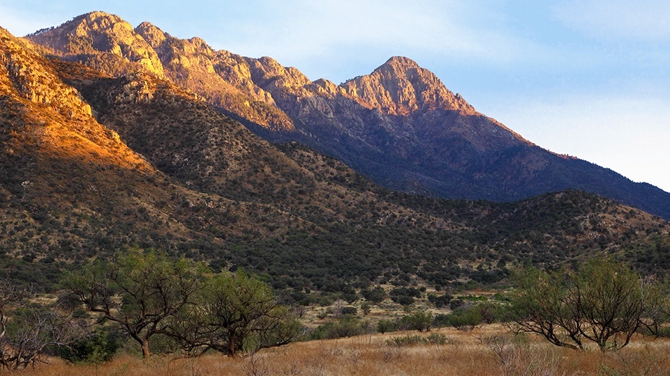
We enter the canyon with Mount Wrightson on the left and Mount Hopkins on the right. Both peaks are named for organizers of the Salero Mining Co., which operated one of the oldest silver mines in the Santa Ritas. Both men were killed by Apaches.
The area’s biodiversity comes from its location at the confluence of four biological regions: the Sierra Madre to the south, the Rocky Mountains to the north, the Sonoran Desert to the west and the Chihuahuan Desert to the east.
Madera Canyon is also a “sky island,” encompassing four life zones as it gains elevation. The drivable portion of the canyon moves from mesquites and prickly pears to semi-desert grasslands dominated by seven species of evergreen oaks.
In partnership with the Coronado National Forest, the Friends of Madera Canyon organization maintains five interpretive areas with trailheads, picnic areas and a campground. The trails lead through the remaining two life zones — ponderosa pines, then mixed-conifer forests — in the upper canyon and the Mount Wrightson Wilderness.
We pick up a trail map and birding list at the Santa Rita Lodge gift shop and linger at its feeding stations, where we quickly count eight of the 15 species of hummingbirds found in the canyon, including several white-eared hummingbirds, considered rare. Our last stop is the Mount Wrightson Picnic Area, where we take in views of the Santa Cruz Valley before heading down and out of the canyon.
Back at the intersection of Whitehouse Canyon and Madera Canyon roads, we turn right onto Forest Road 62, passing the turnoff to the ruins of the old mining town of Helvetia.
We pass mesquite-dotted fields and hillsides heavy with ocotillos, startling two white-tailed deer in a wash. Crossing Box Canyon Creek, the road begins to climb the gentle northern shoulder of the Santa Ritas, emerging into the oak-dotted grasslands typical of Southern Arizona. After 10 miles, as we hit pavement, the landscape opens up to views of the Mustang, Whetstone and Huachuca mountains.
At the intersection with State Route 83, we head north to the tasting room of Charron Vineyards in Vail, where we drink in views of one of the state’s oldest vineyards and the road just traveled.
Note: Mileages are approximate.
Length: 100.6-mile loop (from Tucson)
Directions: From Tucson, go south on Interstate 19 for 24 miles to Continental Road (Exit 63). Turn left (east) onto Continental Road and continue 1.2 miles to Whitehouse Canyon Road. Turn right onto Whitehouse Canyon Road and continue 7 miles to a fork. Veer right at the fork to stay on the paved road, which becomes Madera Canyon Road, and continue 6 miles to the last parking area in Madera Canyon. From the parking area, backtrack 6 miles to the fork. Turn right onto Whitehouse Canyon Road (now Forest Road 62) and continue 0.3 miles to another fork. Veer left at the fork to stay on FR 62, then continue 13 miles to State Route 83. Turn left onto SR 83 and continue 10.5 miles to a dirt road that leads to Charron Vineyards (just past Mile Marker 52). Turn right onto the dirt road and continue 0.8 miles to the vineyard, which is open Fridays, Saturdays and Sundays (drink responsibly). Afterward, backtrack 0.8 miles to SR 83, turn right and continue 6 miles to Interstate 10. Turn left onto I-10 and continue 25 miles back to Tucson.
Vehicle requirements: None
Warning: Back-road travel can be hazardous, so be aware of weather and road conditions. Carry plenty of water. Don’t travel alone, and let someone know where you are going and when you plan to return.
Information: Madera Canyon, www.friendsofmaderacanyon.org; Charron Vineyards, 520-762-8585 or www.charronvineyards.com; Nogales Ranger District, 520-281-2296 or www.fs.usda.gov/coronado