
Prescott National Forest, Prescott
Walk around Prescott’s Courthouse Plaza and you’ll immediately discover that there’s always something happening: fairs, festivals, food ... you name it. Arizona’s first Territorial capital is brimming with activity. But for those seeking a respite from the flurry, a quiet drive through the Sierra Prieta mountain range — with its picturesque views — means you can have your homemade coffeecake from Cuppers and eat it, too.
The drive begins on Copper Basin Road, which is paved for the first few miles and then becomes graded dirt where you enter Prescott National Forest. As you climb deeper into the trees, beware of the occasional truck darting out from the private driveways, and keep your eyes on the road — it becomes bumpy fast. You’ll also want to pay attention to the gas pedal, especially if you’re in a sedan.
Bouncing along, the Sierra Prieta reveals itself. Verdant hills are magnificent and unexpected, especially after the earlier climb through fragrant ponderosa pines. For the next several miles, the road narrows, then twists and turns sharply as you swoop into the belly of the mountain range. As you drop down farther, leaving the forest behind, the temperature rises by several degrees — something to keep in mind during the summer months.
Continuing toward Skull Valley, another big payoff shows up around mile 10.5 — a picturesque panorama of the entire valley, with its Kelly-green patchwork of fields and the Bradshaw Mountains looming in the distance. At mile 12.6, the road dips as it enters a wash (do not tempt fate in inclement weather). Less than a mile later, Copper Basin Road turns back into pavement as it winds into the tiny hamlet of Skull Valley. The idyllic town oozes charm and is certainly worthy of a side trip, particularly to the old Skull Valley General Store, where travelers from around the globe still make pilgrimages to experience a living slice of Americana. You’ll also find the Skull Valley Garage with its three old-fashioned gas pumps.
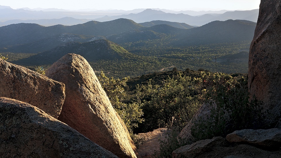
An easy miss, especially if your eyes were on the town, the road at this point becomes Yavapai County Road 10, or Iron Springs Road. It’s a 15-minute drive back to Prescott. Again, if time isn’t an issue, continue to Gurley Street, which turns into Thumb Butte Road. The road goes from paved to graded dirt as you begin climbing. There are several photo-worthy views of Thumb Butte as you ascend, but the best is yet to come. About 4 miles in, you’ll reach Copper Basin Overlook. The views from this point are magical, and you’ll be reminded of Thomas Cole and his divine paintings of American landscapes.
At this point, you can either turn around and retrace your steps or continue on Thumb Butte Road to where it eventually intersects with Copper Basin Road. Hang a left and you’ll be heading out of Prescott National Forest and back into town.
Note: Mileages are approximate.
Length: 34.8 miles to Copper Basin overlook
Directions: From Prescott, drive south on Copper Basin Road for approximately 13.2 miles to Yavapai County Road 10 (Iron Springs Road) at Skull Valley. Turn right onto Iron Springs Road and continue for 17 miles to Miller Valley Road in Prescott. Turn right onto Miller Valley Road and continue for about a mile to Gurley Street. Turn right onto Gurley Street, which turns into Thumb Butte Road, and continue to the Copper Basin Overlook sign. Turn left at the sign and continue for 3.6 miles to the overlook.
Vehicle Requirements: A high-clearance vehicle is recommended, but roads are passable by sedans in good weather.
Warning: Back-road travel can be hazardous, so be aware of weather and road conditions. Carry plenty of water. Don’t travel alone, and let someone know where you are going and when you plan to return.
Information: City of Prescott Office of Tourism, www.visit-prescott.com