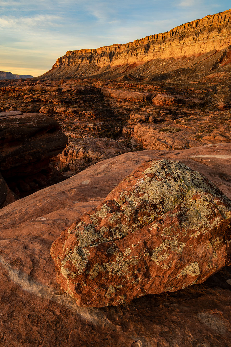
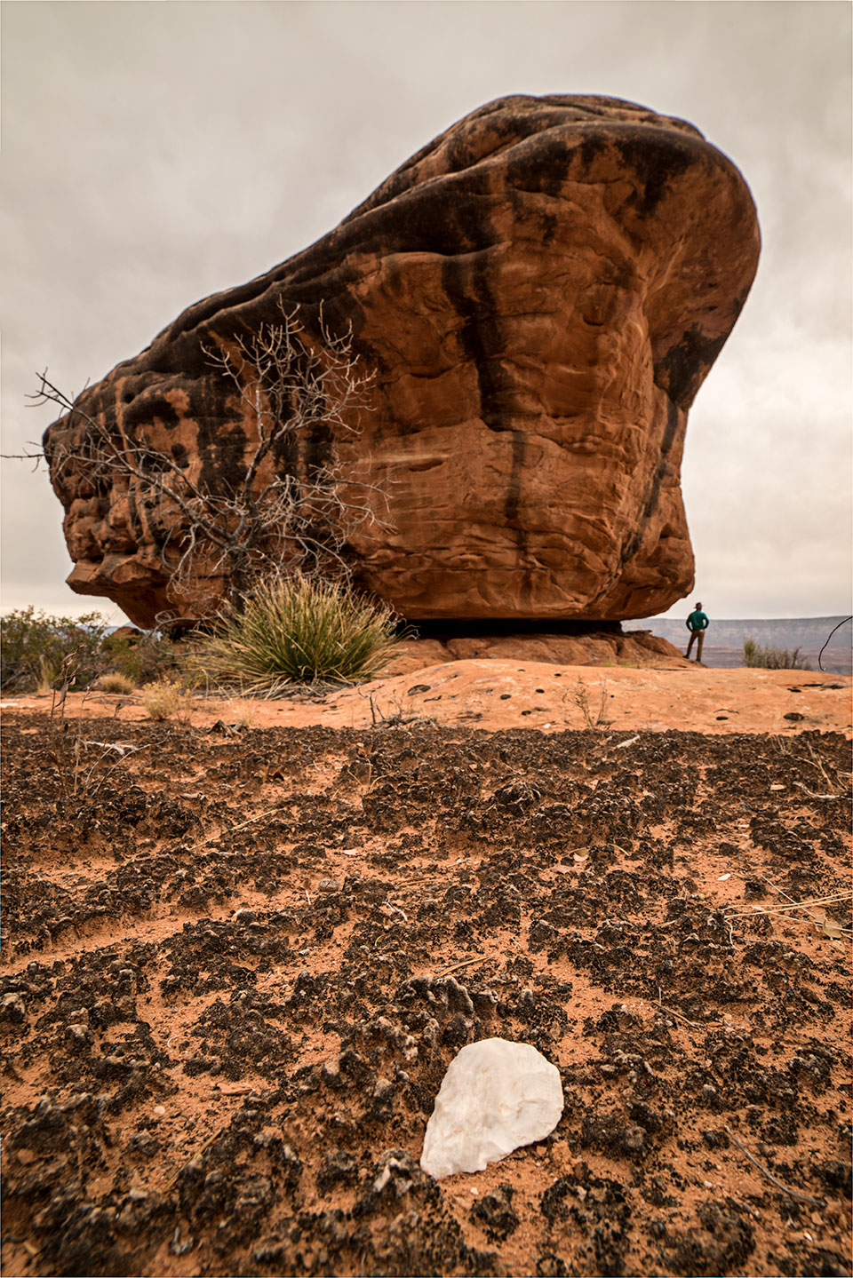
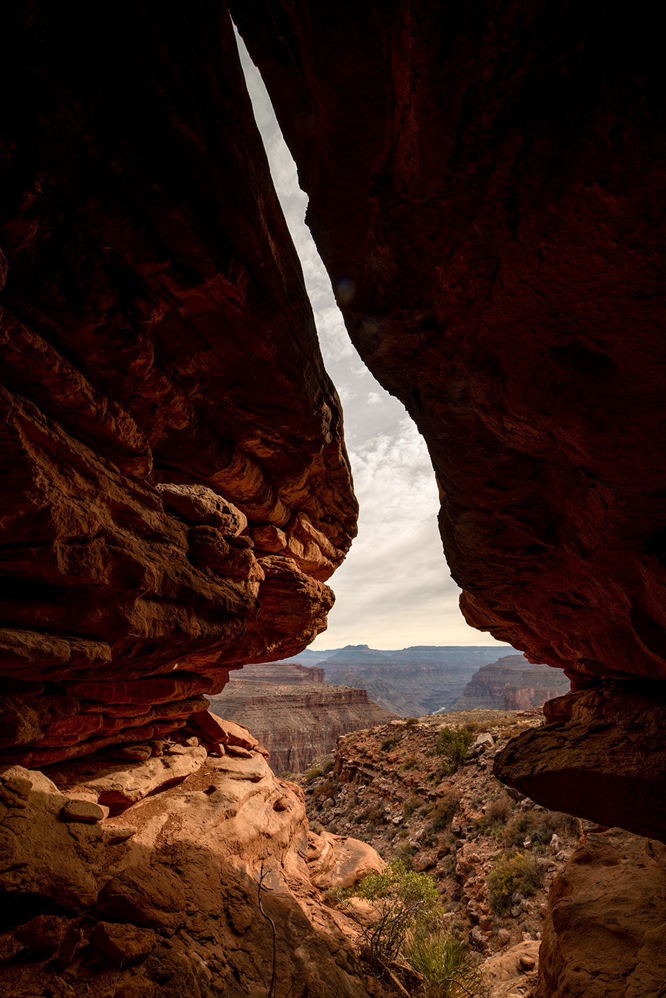
At first glance, the Esplanade doesn’t stun the senses the way a Grand Canyon view from the South Rim does. There is no perfect layer cake of multicolored rock, no glimpses of the magical Colorado River sneaking through a gap far below. No, the Esplanade looks like a rather typical Southwestern scene: a red-rock valley beneath a rampart of buff cliffs. But as one looks more closely, the gauzy expanse begins to reveal itself in layers of detail. There is a dome, a pinnacle, a pile of stone billiard balls 200 feet tall. The sheer scale of the landscape begins to sink in as you discern fingers of canyon slicing through the orange plateau. Soon, the pedestrian red-rock valley has morphed into a 3D world of sculpted amphitheaters, plazas of rock, draws of piñon pine, razorbacks of sandstone. Just as your eyeballs become lost in this endless jungle gym, there appears, at the far edge, a vague shadow — an awful and mysterious gash plunging into darkness, toward some distant underworld.
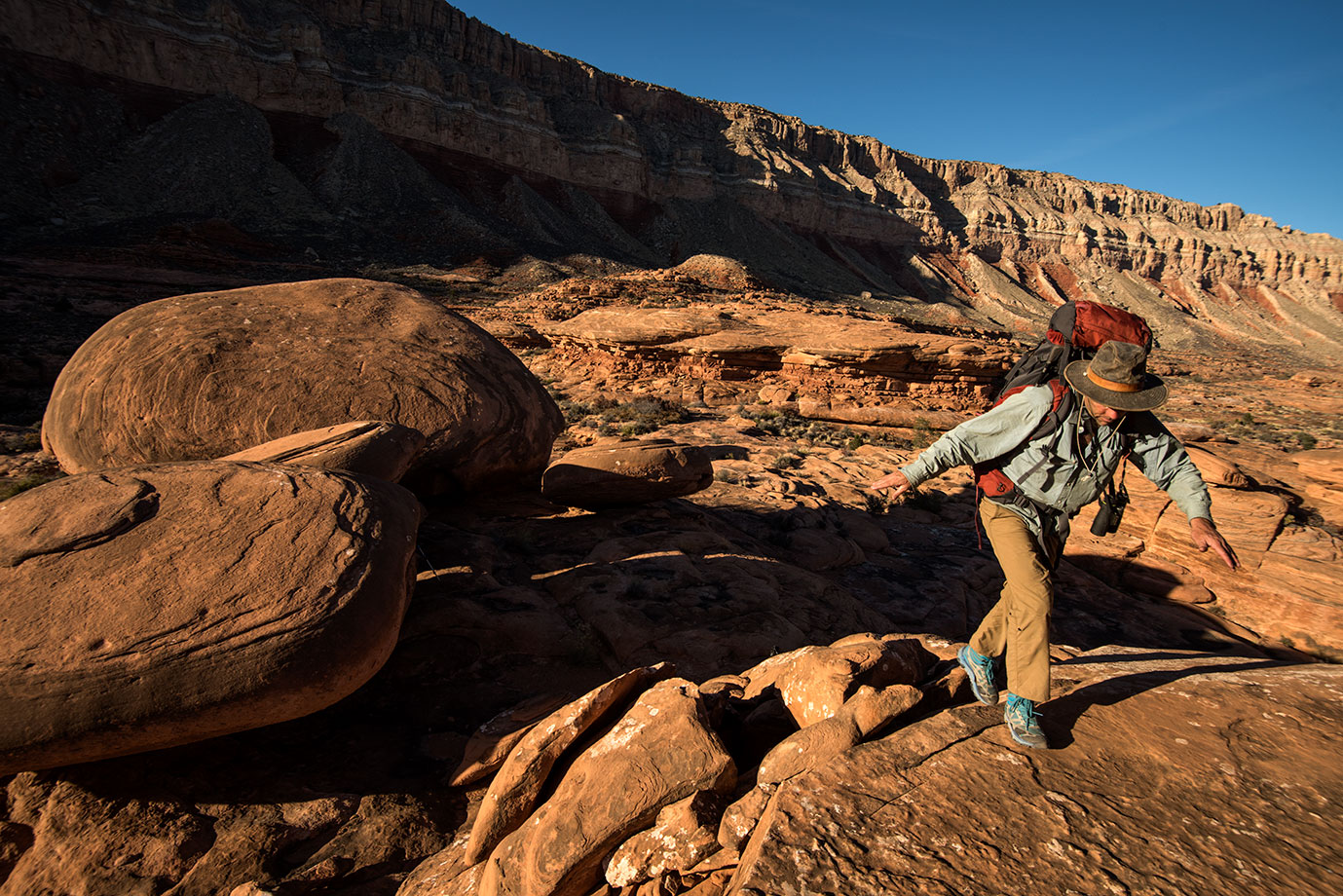
Photographer Bill Hatcher and I schlepped heavy packs as we stepped off the rim into this naked wildland. Our loads weren’t bulging with weeks of food or extravagant luxuries, but we did have water — at 8.3 pounds a gallon. We should have been here after a storm, when depressions in the Esplanade bedrock hold shallow reflecting pools that glisten in the sunshine and readily slake one’s gullet. Instead, nearly two months had passed since the last rain, and the Esplanade was a waterless expanse of dull brown. Our timing was less than ideal.
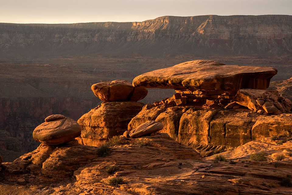
We’d chosen to explore this part of the Esplanade, just west of the popular Thunder River Trail, because it contains a particular rock formation that river runners call the “Chicken Train.” Viewed from Mile 138 along the Colorado, the inexplicable turrets of rock cut a cartoonish skyline, as if the stones have come to life in an animated film: a parade of farm fowl marching along, with their possessions in tow, toward the edge of the abyss. The eye-catching rocks seem untouchable from the river, perched as they are atop 2,000 feet of vertical limestone. But they are alluring.
This was my second attempt at reaching the landmarks. My first try ended well short, with me sipping a dwindling water supply amid a sea of sunbaked stone.
Daunting as the endless Esplanade might seem, its vast stony sidewalks are perfect for walking — hence the name. Geologically, the Esplanade is the bench at the top of the Supai Group, which forms a prominent red cliff about halfway down the Canyon’s colorful bands. Geologist Eddie McKee first described the Supai Group, consisting of four geologic subunits. Esplanade sandstone is the top rock unit. The others all carry an exotic and distinctive sound: Watahomigi, Manakacha, Wescogame — titles that unmistakably originate from the Havasupai people, who dwell below the sandy, pumpkin-colored rocks, along the banks of Havasu Creek on the south side of the Canyon.
Havasu is just one of many tributaries that create huge canyon bays within the Esplanade Platform. We could see the massive side canyon from our perch, near Fishtail Canyon. Here, the Esplanade is just starting to develop into the hanging plateau that soon dominates the Canyon. Despite its prominence, few ever see the Esplanade, because there are no popular viewpoints nearby. The Esplanade is perhaps the most prevalent feature of the Grand Canyon’s geography that remains unknown to the casual observer.
Below the South Rim’s Grand Canyon Village, about river Mile 90, the Esplanade hasn’t yet developed. The top of the Supai Group here is merely a ledge, lost among the stack of cliffs that create the Canyon. East Rim views reveal even less. It’s only downstream, around river Mile 115, that the Esplanade asserts itself into a noticeable terrace. For the next 50 river miles westward, the Esplanade is in full flourish, forming a vast but hidden world within the Canyon: separated from the river below by a deep gorge, isolated from the rim above by sheer cliffs.
The Esplanade gets covered in old lava flows around Mile 175, but it re-emerges in the far western Canyon with a slightly different character. The various phases of the Esplanade are representative of the Canyon’s geologic history, which basically tells us Arizona was a very dry coastline for a very long time, preserving eons of sediment before the Colorado River rapidly sliced through the buried layers. The Esplanade was primarily an expanse of desert sand dunes before it got compressed into rock, and those dunes led straight to the edge of the ocean.
Geologist Wayne Ranney explains: “In the very western portions of the Canyon, the Esplanade sandstone grades into another formation called the Pakoon limestone. This change in rock type is called a facies change, and it documents that the near-shore terrestrial sands were grading into coastal and offshore marine environments. Simply put, land was transitioning to seawater. It’s a neat part of the story.”
This transition zone, the old coastline, comes just before the Grand Canyon ends abruptly at the Grand Wash Cliffs. Out here, the Esplanade forms the South Rim of the Canyon because the upper Canyon layers have eroded away. Here, it’s not a Canyon feature to gaze at; rather, it’s an open landscape Las Vegas tourists cross by the busload to reach the rim. Ranney adds, “The Esplanade is what the Grand Canyon Skywalk is built on.”
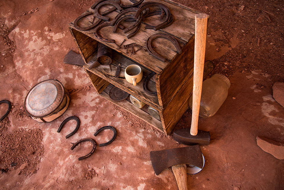
There was no glass-bottomed viewing station where Bill and I stood, much less any human sign except for the one set of footprints, probably a year old, that we kept seeing. Then Bill stopped and pointed: “Is that a square rock?” I pulled up my binoculars, “No, it’s historic stuff,” I said, differentiating it from prehistoric, which we’d already seen that morning at a place called Ghost Rock. Those flowing white figures, painted by Ancestral Puebloans a millennium ago, had an almost cheerful feel to them, calling out at the Canyon’s majesty. The stuff in my binoculars just looked like discarded junk.
It was a bit more than that: an old wooden box, several glass jars, a couple of axes, a canteen, two ceramic mugs, some horseshoes and an arrangement of ancient lithics. On the wall behind were inscriptions: M.V. Adams, Danzil Frost, Ken B., Walapai Johnny. They were dated February 21, 1925. Walapai Johnny made another visit in 1958. That’s an impressive timespan between trips to such a lonely place, but Johnny got around. I’d seen his name in this part of the Canyon before. He was a guide and ranch hand back when cattle still roamed this part of the Esplanade. It never was prime cow country, but the cliffs above and below the platform provided natural barriers to roaming bovines, and in winter, there was just enough water out there to keep them alive. Besides, what a place to ride the range. People like Walapai Johnny, and the cattlemen for whom he worked, eked out an existence here because the landscape had a hold on their souls. It’s a connection shared backward and forward in time, from the Natives of centuries past to folks like me who gain spiritual renewal with too-infrequent forays here.
With such signs of humanity in the area, we held some hope that reliable water was nearby. The map indicated a spring in the canyon bottom below us, but maps lie during droughts like this one. We set out with empty water bottles, dubious they’d be refilled. A bighorn sheep trail led to a cliff edge, which led to a gap, which led to a series of ledges. Near the bottom, greenery appeared, and then a wall of clinging ferns; beneath them was a Jacuzzi-sized pool of clear, cold water. I thought of how many others had gratefully lapped up the liquid from this pool over the centuries, and what it might have meant. A standard resupply on their journey? A part of the day’s chores? A chance at survival? For us, the water hole meant reaching the Chicken Train was again a possibility. Even so, we would have to ration, and we’d likely be plenty thirsty by the time we got back here two days hence.
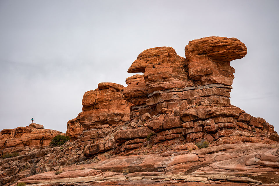
Skidding into gullies, weaving through flats of scratchy black brush, contouring along orange sidewalks and pausing now and then to gaze at some peculiar pictograph, we marched into a setting sun. Camp came upon bare rock, among giant stone mushrooms that overlooked the dark depths of Fishtail Canyon. Looking out toward the river gorge revealed a fiery maze of sandstone fins and, beyond them, the Chicken Train. The entire formation looked distant and unimpressive compared with the many buttes that were closer, and there was talk about not even going out there, saving our water and staying closer to camp. But that was just talk, something to provide an out if we lost our mojo. The fact was, this was my second attempt at reaching those rocks, and I wasn’t too sure there’d be a third. I wanted to float beneath that striking sandstone, someday, and bring my visual full circle. I wanted to get there.
In the morning, we set off on a meandering course, tracing different ledges of sandstone that narrowed and broadened with their own unique rhythm, so that a wide pavement one minute might blend into a vertical cliff the next. But there was always a way up or down or around; it was just convoluted. As we distanced ourselves from camp, I began to make mental notes of the route, correlating our progress with formations that weren’t hard to remember or describe: red-on-white butte, royal crown, soft-serve cone.
As impossibly distant as the Chicken Train had always seemed to be, it appeared before us quite suddenly. I scrambled atop part of the formation before following Bill out to a sombrero- like rock perched on the rim of the river gorge. There was literally no place left to go. So we sat and snacked and looked down on the glinting water we’d always looked up from.
But the Esplanade is not about a destination, or the river, or the rim. It is a place totally unique, a lost world sandwiched within the greatest landscape of the world. As we rimmed out the next afternoon, I grabbed the binoculars and gazed westward, down a corridor of canyons swathed in smoky haze. Esplanade peninsulas overlapped into the distance, each separated by gorges of shadow: Hundred and Forty Mile, Matkatamiba, Havasu. But as my eye drifted farther, the scene became muddier, peninsula after peninsula, seemingly to infinity. I became lost in a sea of stone, and that was just fine with me.