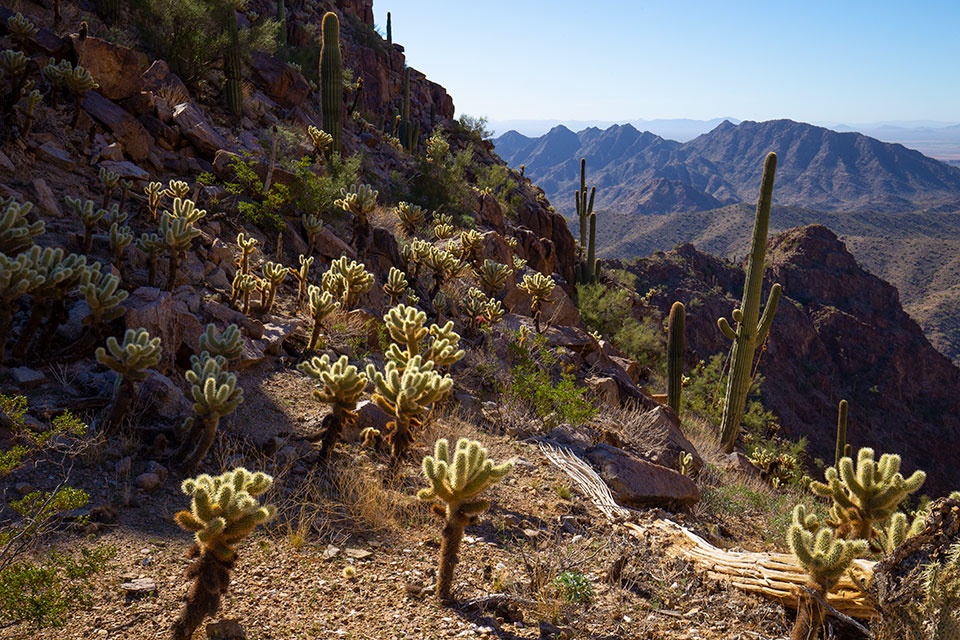
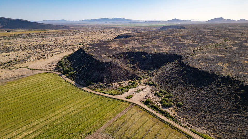
The Gila River sleeps in its bed southwest of metropolitan Phoenix, curled up in a long and lazy bend of dry sand, its water penned behind a series of upstream dams. This section, known as the Great Bend of the Gila, sees few visitors, and while some ranch roads intersect the depressed, tamarisk-choked area where year-round water used to flow, it can be difficult to perceive that a river ever was there.
The relative isolation of this part of the Lower Gila has kept its many treasures preserved. This now-neglected corridor once was the most important “highway” in the southern part of what is now Arizona. Native peoples from all over the Southwest used the Gila as a reliable pathfinder that pointed them toward the Pacific Ocean, and those travelers left trails that have existed for more than 3,000 years. Groups ancestral to 13 modern-day tribes lived and farmed near the river for more than a millennium, and some of them etched their stories into the volcanic slabs lining the banks. When Juan Bautista de Anza and his large entourage clanked past in 1775 on their way to claim San Francisco Bay for the king of Spain, they traveled through a lush riparian concourse teeming with ducks and beavers.
Now, a coalition that includes environmentalists, archaeologists, historians and tribal governments is calling on the White House to create Great Bend of the Gila National Monument to extend permanent protection to the fragile strand of cultural sites, art and wildlife along the vanished river’s course.
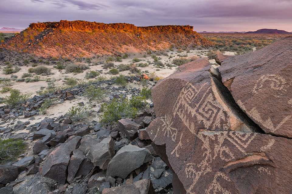
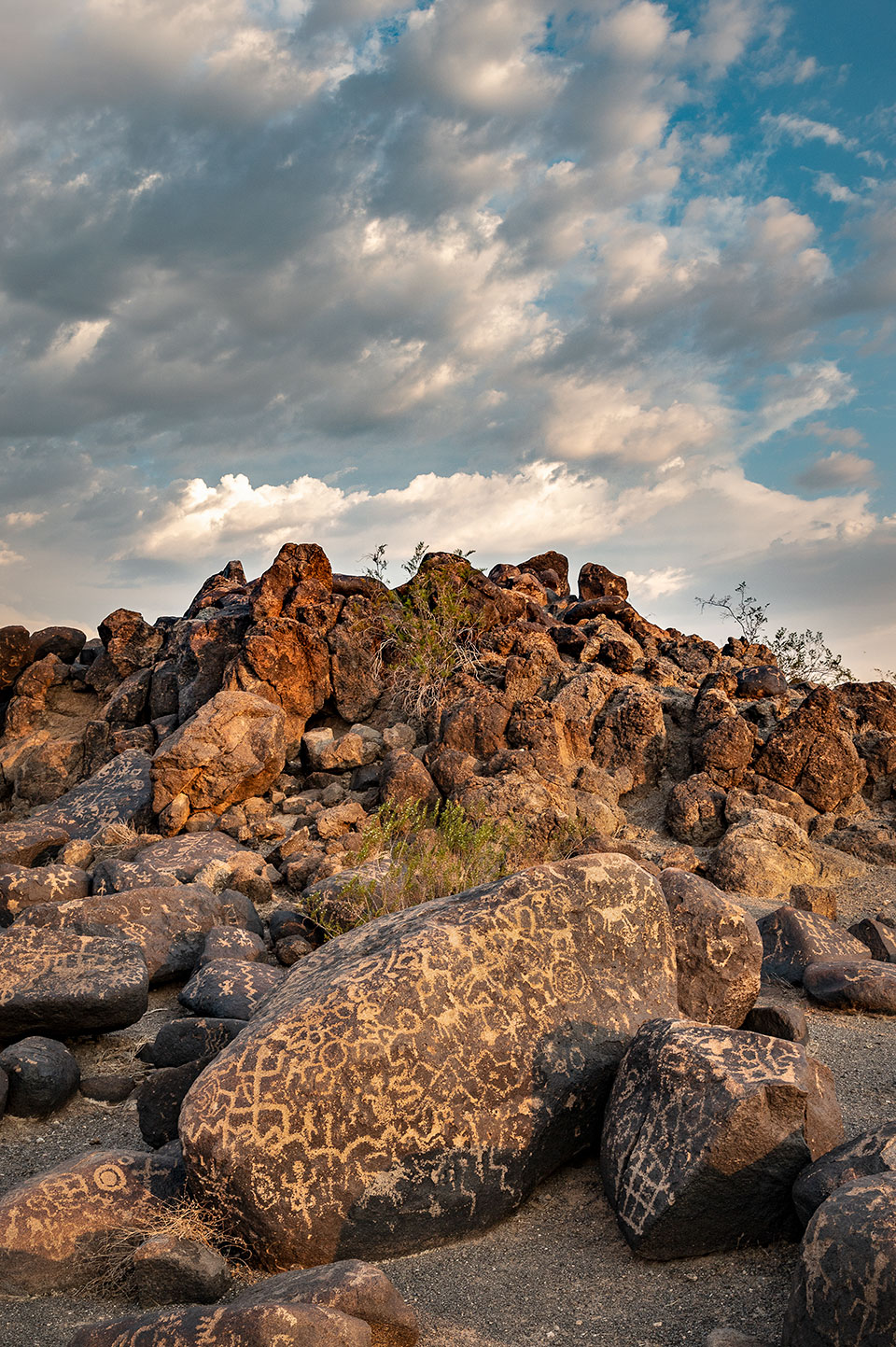
“It’s probably one of the densest and largest concentrations of petroglyphs anywhere in America,” says Skylar Begay, director of tribal collaboration in outreach and advocacy for Archaeology Southwest. “They tell stories — they’re not just art. This place was also a huge area of trade and migration. You’ll find obsidian from all over the Southwest and shells from the Gulf of California out there.”
The Antiquities Act of 1906 gives presidents the authority to set aside lands for “the protection of objects of historic and scientific interest.” Among its first uses, by Theodore Roosevelt, was the creation of what later became Grand Canyon National Park, and it’s been employed nearly equally by Republican and Democratic presidents ever since, often as a preemptive move against mineral extraction from beautiful or fragile places.
No such mining threat now exists to this stretch of the Gila. The potential harms are more mundane: people spraying graffiti on the petroglyphs, driving their all-terrain vehicles over cultural sites or letting livestock wander into fragile areas. And as metropolitan Phoenix continues its seemingly unstoppable march outward, it’s conceivable that real estate professionals will soon be contemplating land swaps here for new subdivisions. “We’re hoping to get ahead of the curve of development,” Begay says. “The West Valley of Phoenix has some of the fastest-growing cities in the country.”
This would not be the first time the commercial fingers of the Phoenix area would reach into this remote place. Just as the ex-Confederate soldier Jack Swilling saw a moneymaking opportunity by digging out the old Hohokam canals in the Salt River Valley, a generation of farmers saw how the vanished Native farmers had already laid out a hydrological honeycomb along the Great Bend of the Gila. They excavated silted-up canals and dug new ones, giving them names such as Enterprise Canal, Farmers Canal and Citrus Ditch.
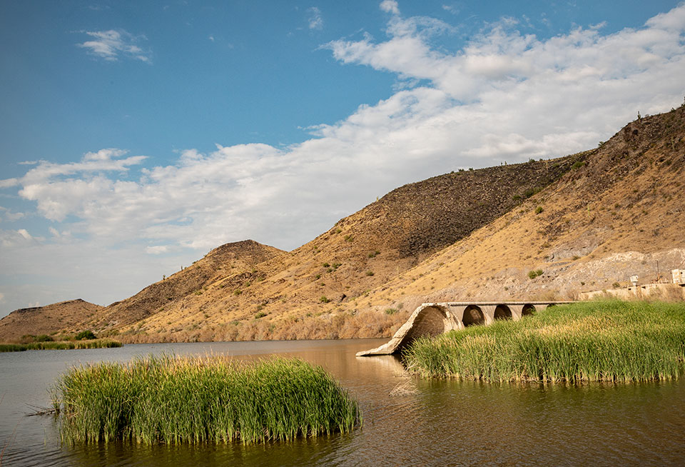
Growers with more capital put up diversion dams, which invariably jammed up with sludge and debris. One of the more determined settlers, Frank Gillespie, paid $320,000, the equivalent of nearly $6 million today, for a dam nearly a quarter-mile long to water fields of cotton, and a bridge downstream from the dam soon became a link in U.S. Route 80, also known as the Dixie Overland Highway. But the dam suffered a partial collapse in 1993, and much of the water that flows there now comes from the 91st Avenue Wastewater Treatment Plant in Phoenix. The arched ruins of Gillespie Dam, just outside the proposed monument’s boundaries, stand as a declaration of humanity’s ongoing hydrological work in the Lower Gila basin.
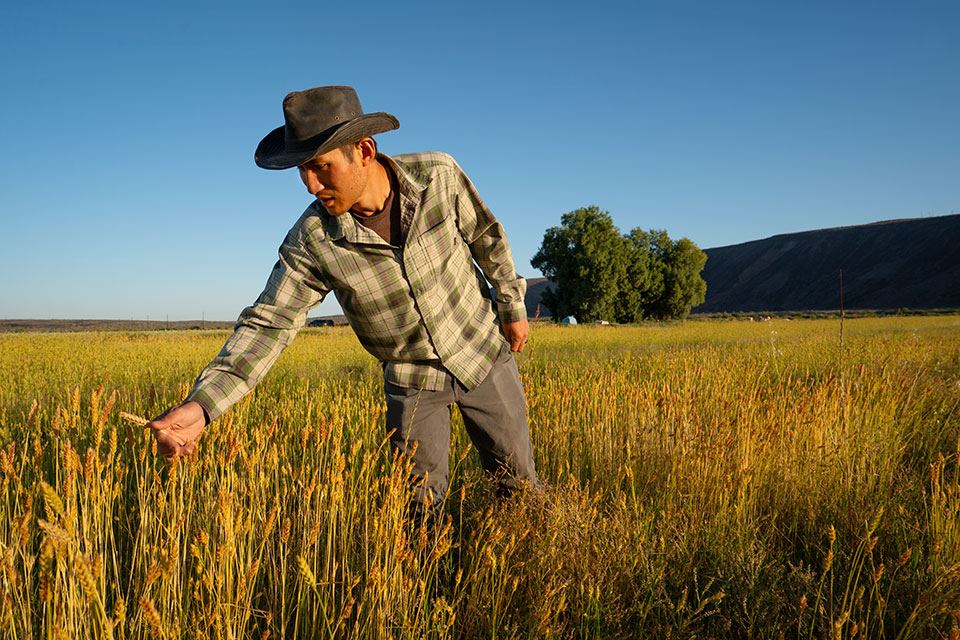
Living farms operate here, too, and not just the corporate concerns that grow thirsty, irrigated commodities such as alfalfa and cotton. In the ocher light of sunset, a young soil scientist named Yadi Wang pulls up a tuft of clover at Oatman Flats Ranch, northwest of Gila Bend, and shows off the dirt clinging to the roots: damp and fertile, as brown as cocoa, a delicate layer of soil coating each tendril. “This is the biomass,” he says. “This is what I’m talking about. People say you can’t do this in the desert. But we have to find a way to work with nature. That’s the whole thing.”
Wang is the manager of the ranch, a family-owned spread on the Gila’s banks that’s making strides in conservation and non-industrialized growing methods. The farm used to feature cotton but went fallow for a decade; now, it grows an impressive amount of winter heirloom wheat, including White Sonora wheat. Summer cover crops include sorghum, millet, sunflowers, peas, beans and squash, which help suppress Bermuda grass and tumbleweeds.
“This might look messy,” says Wang, showing off the jumble of greens from the driver’s seat of a pickup truck. “But denser crops create their own water cycle. During hot summer days, it can be 25 degrees cooler in the soil, and it creates a thick boundary. There’s lots of dew in there.” During the scorching hot and dry July of 2023, Wang walked through one of these thick clusters and found his pants soaked from the knees down.
David Wallace
Come harvest time, the wheat gets separated from the chaff, and a seed-cleaning process then separates the wheat from weed seeds with a 98 percent purity rate. And insects are rarely a problem, even though Oatman Flats Ranch uses no fertilizer or pesticides. Instead, it builds soil health and employs seed-saving practices known for generations among Indigenous people to create a more diverse epigenetic expression in the plants, making them more resistant to insects. “We have so many insects in here, but they’re not interested in the wheat — it has a built-in self-defense mechanism,” Wang says. “A lot of good practices have been forgotten. We’re trying to bring them back.”
Wang is an unlikely desert farmer. Born in China, he came to the U.S. in 2015 for a walk-on opportunity in college basketball, then earned a Ph.D. in soil and water science from the University of Arizona. He left academia because of his commitment to land stewardship and community agriculture — a passion he picked up from his father-in-law, a sixth-generation farmer. And Wang has found a place to live that passion in this bend in the senescent river, which occasionally springs out of its slumber into a raging spasm, a reminder of its latent power.
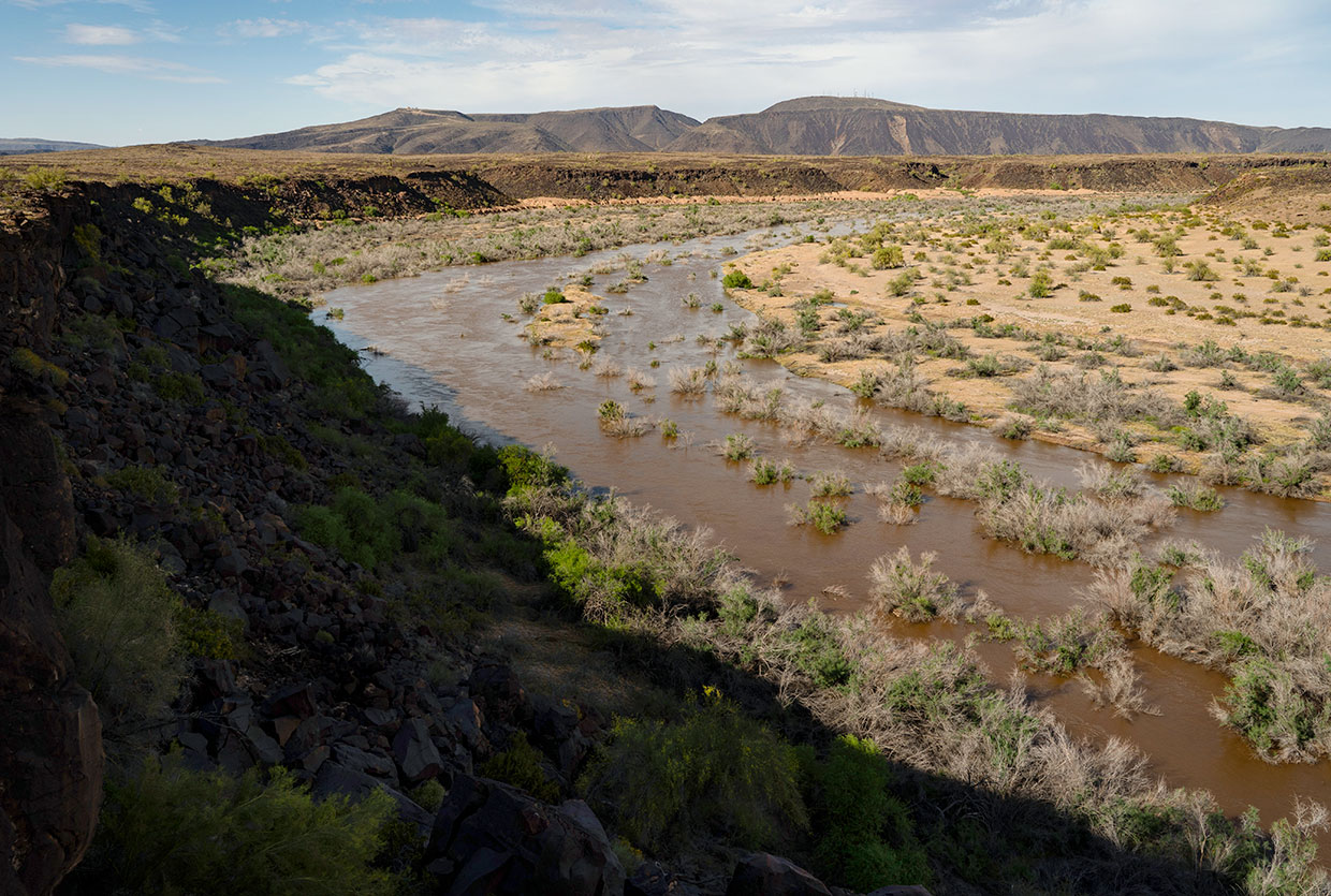
Heavy rains came down in March 2023, and the U.S. Army Corps of Engineers was forced to release 3,800 cubic feet of water per second out of the sluice gates of Painted Rock Dam 7 miles upstream, threatening an archaeological site at the ranch. Wang and others at the ranch used a rented bulldozer and mapping drones to build temporary berms to save it, barely sleeping for days on end. For a dammed-up waterway that barely trickles even during the wettest seasons, this was a remarkable explosion, and for a while, reaching the ranch’s farmland required kayaking across the river. Although the Gila has since gone back into hibernation, it’s easy to perceive its latent vitality — a snake in waiting — while hiking out here in the valley of low volcanic mesas with the brooding hump of Oatman Mountain looming above.

The owner of the ranch, Dax Hansen, is a native of the Phoenix area and now works as a technology lawyer in Seattle. His grandfather Ray Judd Hansen bought the 665-acre spread in the 1950s as a place to run cattle and later used it to raise horses and grow cotton. When the ranch started to fail and go fallow in 2018, Hansen and his wife, Leslie, bought it from his aunts and uncles as a place to experiment with what he called “preservation agriculture,” an ethic that extends not only to using Indigenous practices such as seed saving, but also to stewarding the valley’s considerable human heritage.
Out on the southern edge of the property, Hansen can point out the site of an abandoned stagecoach station, as well as a dugway blasted out of the magma by the Mormon Battalion in 1846. Not far away, a lonely sign marks the spot where most of the Oatman family of pioneers from Illinois was massacred by Yavapai raiders in 1851. And along the river walls are dozens of petroglyphs, both out in the open and sequestered in natural galleries. According to Archaeology Southwest, they’re among an estimated 100,000-plus drawings of ancient character within the proposed monument — one long museum along the river.
The Louvre of this region might be said to reside at Painted Rock Petroglyph Site, a mound of volcanic boulders not far from Oatman Flats Ranch where a spectacular display of art has been chiseled and pounded into the stone over thousands of years. As writer Gregory McNamee wrote in Arizona Highways nearly 20 years ago, the site can be seen as “part museum, part historical document, part newspaper, part church, a place that enshrines ancient aspirations.” Perhaps the pictures were meant to symbolize a good hunting season, praise a deity or memorialize a peace agreement. The more abstract shapes made by the older inhabitants sometimes appear to be in dialogue with the more literal bird and shield designs of the Hohokam people, suggesting a belief in an ancestral kinship and a spiritual continuum that spanned the centuries.
Wang sees the sustainable practices at Oatman Flats Ranch as a part of that cycle. An average day might find him patching up a leaking ditch, fixing machinery, studying the chemical properties of the silty bottomlands or selling the ranch’s organic flour at farmers markets in the state, among many other duties. “There’s no pattern,” he says. “Every day is a new day. It excites me to see life coming from all different directions. We’ve never had a shortage of life on this farm.”
The drive to create a national monument at the Great Bend of the Gila will be subject to the whims of the current president or a future one, along with the changing winds of land-use politics. The Arizona Farm Bureau has signaled its opposition, citing a possible reduction in federal grazing lands. (Previous bills, though, have specified that the monument would not affect existing grazing rights.) Another tricky question is the status of the working farms within the corridor, which likely would be grandfathered in as inholdings — privately owned islands within the monument.
That question doesn’t change Hansen’s bigger plan of conservation, not only of scarce water but also of the human heritage of the Gila River Valley. “I’m doing everything that I can do to preserve the legacy of that land to make sure it’s available for future generations,” he says. “For me, it’s not just a piece of dirt. I’m more of a conservationist than a farmer.” Or, as Wang puts it: “We’re not trying to own it, but to pass it on to the future.”