
San Carlos Apache Tribe, Globe
The road to Point of Pines Lake (Indian Road 8) plucks travelers from brushy desert and leads into a countryside that’s cracked open and wide. The road winds through shimmering grasslands, where horizons spread out and rough hills prop up a sky of epic proportions. Elk and pronghorns graze the high meadows, and Rocky Mountain bighorn sheep clamber up impossible cliffs. Black bears prowl the woodlands, and eagles, herons and ospreys fish the waters of faraway lakes ringed by ponderosa pines.
Indian Road 8 departs from U.S Route 70 east of Globe and crosses the sprawling backcountry of San Carlos Apache Tribe land. Created by Congress in 1897, the tribe's land covers 1.8 million acres and shelters seven biotic communities. On this drive, it feels as if you pass through every one.
A recreation pass is required for non-tribal members, so pick one up before you begin. They can be purchased for $10 at the Circle K in Globe, the Bashas’ in Peridot or the tribe’s Recreation and Wildlife Department office. Be sure to specify if you intend to fish or camp.
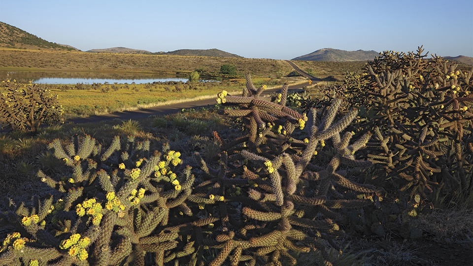
The narrow strip of pavement curls into the soft embrace of the hills, brushing past Mount Triplet, where its distinctive trisummit bulk is graced with the tribal seal. After 6 miles, you’ll crest a high plateau blanketed by Antelope Flats. Rolling meadows push the hills back from the road. Splashes of wildflowers and clusters of chain-fruit chollas — a shaggy, forlorn little forest — are the only interruption in the sea of grama grass.
You’ll pass at least a half-dozen stock tanks along the way, thumbprint ponds, often with horses grazing nearby. After another brief climb, you’ll cross Ash Flats, an expansive prairie and the most likely place to spot pronghorns, looking fine and fleet as they stand chest-deep in the waves of summer grass and sunflowers.
The road makes a final climb along the high shoulder of rocky slopes with a couple of pullouts to enjoy sweeping panoramas. Pay attention for the resident herd of Rocky Mountain bighorn sheep amid these stony formations. You might also spot small cliff dwellings here, but don’t get any closer — they’re off-limits without a guide.
As you approach the 6,644-foot-high Barlow Pass, a mixed woodland of oaks and pines closes in. At about the 51-mile mark, a small sign indicates the left turn to Point of Pines. The 3.5-mile gravel road leads you to the edge of the slender lake, which is cradled by a healthy stand of timber.
The lake is stocked with rainbow and brown trout, and you’ll need a separate permit to fish. Continue through the day-use area on a rutted dirt road to reach the campsites. The lake makes a lovely background for a picnic, but come prepared. There are no tables, and the vault toilets are not regularly maintained. Of course, you didn’t drive all this way for a few creature comforts. You came for the magnificent drama, and there seems to be no end of it on this lonely road.
Note: Mileages are approximate.
Length: 54.5 miles one way
Directions: From Globe, go east on U.S. Route 70 for 24 miles to the turnoff for Point of Pines Lake (Indian Road 8).
Vehicle Requirements: The road is paved except for the last 3.5 miles. This portion can be managed in a sedan.
Travel Advisory: Permits from the San Carlos Apache Tribe are required for recreation and fishing on tribal land.
Warning: Back-road travel can be hazardous, so be aware of weather and road conditions. Carry plenty of water. Don’t travel alone, and let someone know where you are going and when you plan to return.
Information: San Carlos Apache Tribe Recreation & Wildlife Department, 928-475-2343 or www.scatrecreation.org/