
Navajo National Monument, Navajo Nation
With the possible exception of the Thunder River Trail in Grand Canyon National Park, there aren’t any hikes in Arizona with a bigger payoff than the trek to Keet Seel. The sights along the way are incredible, too, but when you first lay eyes on the unimaginable monument embedded in Navajo sandstone — an ancient ruin more than seven centuries old — you’ll understand the exaltation. However, before you can see it, you’ll have to do some planning.
The trail, which is located in Navajo National Monument and can be done as a day hike or an overnight, is limited to 20 people a day. That means you’ll need a reservation. You’ll also need to attend an orientation the day before. The National Park Service has any number of reasons for requiring the lesson, the most important being the protection of the ruins. Another reason is to scare hikers just enough to give them a healthy respect for what’s ahead, including the threat of quicksand, flash floods, rattlesnakes and West Nile virus. What’s more, the trail is open for only a few months in the summer, when the searing high sun deters all but the most determined.
If you make the list and get through the paperwork, you’ll start the hike the next morning, about a quarter-mile from the monument’s visitors center. The route begins as a narrow jeep road, which, for the first three-quarters of a mile, overlaps the trail to Betatakin. (Betatakin is another ancient site protected by the park — a third site, Inscription House, has been closed to the public since 1968.)
About 10 minutes in, you’ll pass through a weathered gate that leads to a small dirt parking area. Five minutes later, there’s a second gate, which marks the boundary of the Navajo Nation. The jurisdiction at this monument is unique, and complicated, but here’s the gist of what you need to know: The ruins are on federal land; the space in between is Navajo. Be respectful. Leaving the designated trail even briefly without a tribal permit is illegal.
Despite the change in jurisdiction, the terrain remains the same as you approach Tsegi Point, which offers incredible views of Navajoland. From there, the trail switches downhill for 1,000 vertical feet into the main branch of Tsegi Canyon. After that, the trail turns to beach sand and segues into a second set of switchbacks. Ten minutes later, you’ll arrive at Laguna Creek, and the start of a long day of sidestepping quicksand.
The creek is about 30 feet wide where the trail first crosses, but it’s not a solid sheet of water. There are patches of wet sand rising up in places. Sometimes, that’s quicksand. There are rocks, too. All sizes. When crossing, you have to plot a course, aiming for the rocks.
Following the canyon floor, you’ll come to a giant boulder that marks the entrance to Keet Seel Canyon. The rest of the way, it’s hard to get lost. All you have to do is stick with the creek and avoid any natural disasters.
Like all of the great canyons in Arizona, it’s hard to put Keet Seel Canyon into words. Photos struggle, too. It takes all five senses. You have to look out at the recurring canyon walls, hear the screeching of peregrine falcons overhead, smell the sweet scent of penstemons, feel the contrast of rock and sand along the creek, and taste the high-desert air.
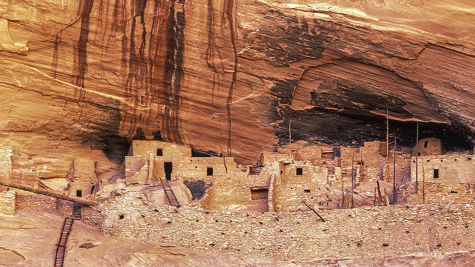
Heading north, you’ll cross the creek multiple times, pass a couple of waterfalls and eventually arrive at Keet Seel Campground. Surrounding the campground is a grove of ancient cottonwoods — a huddle of venerable sentries — and through the trees, you’ll get your first glimpse of Keet Seel (Kits’iil), which, in Navajo, loosely translates to “broken pottery scattered around.” At first, you won’t see the ruins — they’re camouflaged by man and Mother Nature. But then you’ll do a double take and think, Well, I’ll be damned.
From the big trees, the ruins are only 500 yards away, but it’s a journey of more than 700 years. That’s a powerful notion that’s part of an even bigger payoff — one that grows stronger as you climb the long wooden ladder into the hallowed halls of prehistory.
Length: 17 miles round-trip
Difficulty: Strenuous
Elevation: 7,298 to 6,710 feet
Trailhead GPS: N 36˚40.983', W 110˚32.528'
Directions: From downtown Flagstaff, go north on U.S. Route 89 for 66.1 miles to U.S. Route 160. Turn right onto U.S. 160 and continue 62.7 miles to State Route 564. Turn left onto SR 564 and continue 9 miles to the Navajo National Monument entrance. From there, continue another 0.3 miles to the visitors center.
Special Consideration: Reservations are required and National Park Service fees apply.
Vehicle Requirements: None
Dogs Allowed: No
Horses Allowed: No
USGS Map: Keet Seel Canyon
Information: Navajo National Monument, 928-672-2700 or www.nps.gov/nava