
Santa Rita Mountains, Madera Canyon
Like jaguars and ocelots, elegant trogons are rare in Arizona. However, they have been spotted. And photographed. Just not very often. That’s why the colorful bird from Mexico is considered the Holy Grail for birders. It’s related to the quetzal, and if you see one, consider yourself lucky. If you don’t, don’t worry. Your trip to Madera Canyon won’t be without reward. That’s because this is one of the most beautiful places in the Southwest.
In addition to the elegant trogon — and 199 other species of birds — the area is home to black bears, mountain lions, deer, coyotes and coatimundis. There are big trees, too, and panoramic views, along with about a dozen hiking trails, including the Bog Springs/Kent Spring Loop.
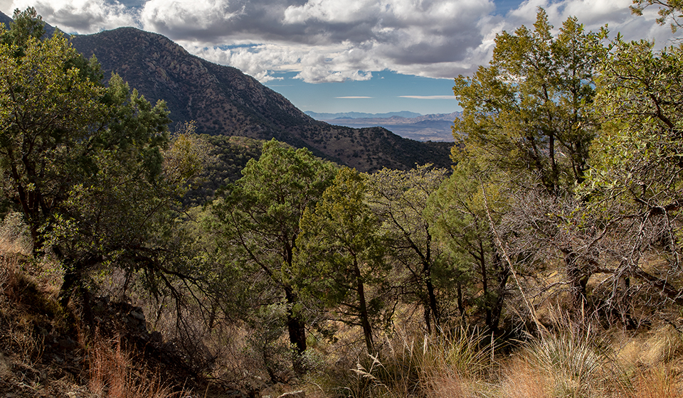
The trail begins in the Bog Springs Campground — at site No. 13. The parking area, however, is located around the corner, at the upper end of the campground. It’s a short walk from one point to the other. From the trailhead, the rocky track dips into a dry wash lined with yuccas, sycamores and alligator junipers. As you climb out, you’ll start seeing silverleaf oaks and come to an intersection. The trail to the right leads to a picnic area, but you’ll go the other way. And when you do, look to the southeast, where the views of Mount Wrightson will inspire a more ambitious return to this inviting canyon.
About 10 minutes later, the trail splits again. The Bog Springs Trail goes left; the Kent Spring Trail goes right. This is the beginning of the loop, and you can go either way, but you might be happier going clockwise, because the climb is more gradual in that direction — the Kent Spring Trail is steep at the top, and most hikers prefer doing that section as a downhill. It’s up to you.
Veering left, you’ll begin a long slog up the western slope of the Santa Rita Mountains. The canopy thickens as you go, and the trail skirts a steep ravine. Fifteen minutes later, after a moderate recurrence of huffing and puffing, you’ll come to a short spur that leads to Bog Springs. It’s worth a look.
Back on the trail, the ascent continues around a deep side canyon. It’s a lush pocket that stands out as one of the most impressive riparian areas in Southern Arizona. In particular, the basin is lined with a neat row of massive sycamores. It looks as if they were planted there.
Beyond the trees, the trail makes its first real switchback, which helps mitigate the gradient — this hike is more difficult than it looks on paper. Above the switch, you’ll get a long-distance look at Josephine Saddle, where, on November 15, 1958, three young Boy Scouts, ages
12 to 16, died when they were caught in a sudden snowstorm. It’s a good reminder that when you’re hiking in Arizona, you need to check the forecast before you leave the house. Flash flooding in the deserts and snow in the mountains can be deadly.
Continuing up, you’ll start seeing some small ponderosas mixed in with the other vegetation. A few minutes later, things level off as the trail crosses a small rock slide. This is the high point of the hike (6,595 feet). From there, you’ll start moving downhill, and along the way, the forest gets thicker and the trail itself crosses a creek — it’s just a trickle, but it’s a lifeline.
Just below the creek, the trail arrives at Kent Spring, which is a good place to sit and catch your breath. And maybe look for birds. When you’re ready to leave, don’t be confused by the trail that continues uphill. Intuitively, you’ll think that’s where you’re supposed to go, but that trail heads east, toward Armour Spring. Instead, look for the Kent Spring Trail, which drops sharply to the right and follows an old jeep road downhill, past Sylvester Spring and back to the trailhead. If you’re lucky, you’ll see water running in the streambed that parallels much of the trail. And if you’re really lucky, you’ll see an elegant trogon or an ocelot. But don’t hold your breath.
Length: 5 miles round-trip
Difficulty: Moderate
Elevation: 5,120 to 6,595 feet
Trailhead GPS: N 31˚43.600', W 110˚52.501'
Directions: From Tucson, go south on Interstate 19 for 24 miles to Continental Road (Exit 63). Turn left onto Continental Road and continue 1.1 miles to Whitehouse Canyon Road. Turn right onto Whitehouse Canyon Road, which merges into Madera Canyon Road, and continue 12.1 miles to the Madera Canyon Recreation Area and the Bog Springs Campground. Turn left into the campground and follow the loop drive for 0.6 miles to the trailhead parking area.
Special Consideration: A $5 day pass is required.
Vehicle Requirements: None
Dogs Allowed: Yes
Horses Allowed: Yes
USGS Map: Mount Wrightson
Information: Nogales Ranger District, 520-281-2296 or www.fs.usda.gov/coronado