
Santa Rita Mountains, Coronado National Forest
Sonoita, Arizona, isn’t what most people think of when they think of Arizona. The area doesn’t feature any saguaros or grand canyons or red rocks. Instead, it’s dominated by rolling hills and grasslands, with several impressive mountain ranges on the perimeter. In some ways, the topography looks more like Oklahoma than Arizona, which is one reason Rodgers and Hammerstein filmed the exterior scenes for Oklahoma! in the nearby San Rafael Valley. It’s a unique environment that provides a beautiful backdrop for Passage 5 of the Arizona Trail.
Known as the Santa Rita Mountains segment, Passage 5 runs for 13.5 miles on the leeward side of the range for which it’s named. This month’s Hike of the Month is a segment of that segment, one that begins at Kentucky Camp, which was built more than a century ago as the headquarters for the Santa Rita Water and Mining Co. It later served as a ranch headquarters, and in 1989, it was acquired by the Coronado National Forest. Today, it’s a great place to begin a hike.
From the trailhead, a narrow jeep road leads downhill for a quarter-mile to the camp, which consists of five adobe buildings: the ranch headquarters, an assay office, the remains of an old barn and two cabins — one of the cabins can be rented through the “Rooms With a View” program. On the other side of the camp, the trail passes through a gate and enters Kentucky Gulch, a narrow passage of grama grasses, scattered junipers and a steady stream of oaks. You’ll also notice some low mounds and shallow pits. They’re the remains of small-scale mining efforts that began in the 1870s.
About 20 minutes in, you’ll pass through another gate and see a giant Emory oak on the right. The big trees, which are evergreens, can reach heights of 60 feet, and their acorns feed quail, Steller’s jays, turkeys, squirrels, deer and other resident wildlife. The oaks are a common sight along the trail. Keep your eyes peeled for horses, too — the AZT was built as much for horseback riders as hikers, and this stretch is especially popular with equestrians.
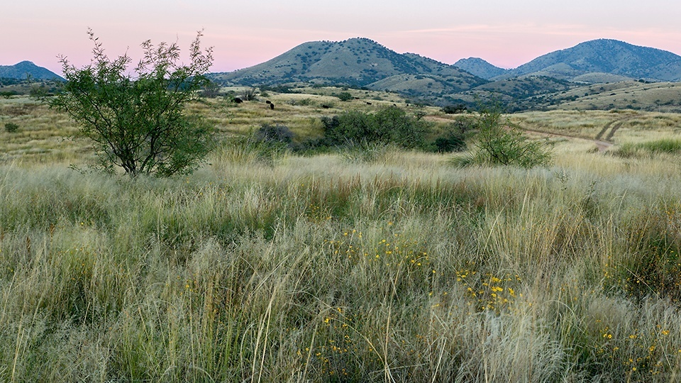
Continuing southeast, the trail crosses into Fish Canyon and starts switching uphill into a thicket — look for gray-breasted jays, whose calls include a loud, ringing week given singly or in a series. Fifteen minutes later, the trail emerges on a high ridge that offers long views of the Santa Rita, Patagonia, Huachuca and Whetstone mountains. At the top, the trail connects with Forest Road 4111 and follows the rocky road to the southwest. If you use your imagination, this part of the trail is reminiscent of trekking through the Italian countryside. Without the small villages.
After 30 minutes on the high road, you’ll see a sign on your left for the Arizona Trail — the AZT is extremely well marked. Alligator junipers and yuccas line the narrow path, along with the tall grasses that are ubiquitous to the region. Ten minutes later, you’ll arrive at a gate and begin a gradual descent. If you look down at your feet, you’ll see the rusting remains of an old pipeline that was installed by the Santa Rita Water and Mining Co. There’s buried pipe throughout the area, but because of the outcroppings of hard limestone in this area, the pipe couldn’t be buried as deep.
Continuing downhill, the trail winds through a grove of beautiful trees and arrives at a ridge that overlooks Gardner Canyon. From there, it’s a steep drop for a quarter-mile to the Gardner Canyon Trailhead, which is the turnaround point for this listing. However, if you’re up for more, the Arizona Trail continues for another 75.1 miles to the U.S. border with Mexico. It’s a beautiful stretch that features mountains, canyons and, as Rodgers and Hammerstein discovered, the rolling hills of Oklahoma!.
Length: 7.5 miles round-trip
Difficulty: Easy
Elevation: 5,446 to 4,986 feet
Trailhead GPS: N 31˚44.867', W 110˚44.506'
Directions: From Tucson, go east on Interstate 10 for approximately 21 miles to State Route 83. Turn right onto SR 83 and continue 21.2 miles to Gardner Canyon Road. Turn right onto Gardner Canyon Road and continue 0.8 miles to Forest Road 163. Turn right onto FR 163 and continue 4.4 miles to the parking area for Kentucky Camp. The trailhead is at a gate to the left.
Vehicle Requirements: None
Dogs Allowed: Yes (on a leash)
Horses Allowed: Yes
USGS Maps: Mount Wrightson, Sonoita
Information: Nogales Ranger District, 520-281-2296 or www.fs.usda.gov/coronado; Friends of Kentucky Camp, www.kentuckycamp.org